


|
||

|

|
|

|
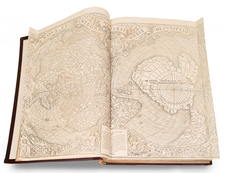
Fourth State of Van Den Keere’s World Map.
Fine old color example of Pieter van den Keere's decorative map of the world, first issued in 1608.
The present edition was issued by Jan Jansson in c. 1628 and is considered to be one of the supreme examples of the golden era of Dutch Baroque cartography.
The map is skillfully derived from Willem Janszoon Blaeu's double-page world map of 1608, but, through van den Keere's extensive annotations, the present map includes far more information about potential discoveries in the Arctic, Antarctic, and Australia.
Cartographically, the map's lineage can be traced through the Blaeu image to Petrus Plancius's wall map of 1592. The map incorporates some of the classic cartographic hypotheses of the period, including an elongated Northwest Coast of America, a massive mysterious southern continent (Antarctica) with a very narrow strait between it and South America, as well as an incomplete New Guinea that is attached to the southern continent.
The map features a lengthy notation to the left and right of the large cartouche titled 'America' that discusses whether in fact the apocryphal Anian Straits (at the location of modern-day Alaska) and the Davis Straits actually join to form the Northwest Passage. Related to this aspect, a sprinkling of English names in the Canadian Arctic is included as a result of Martin Frobisher and John Davis's explorations in search of the Northwest Passage in 1576-1587.
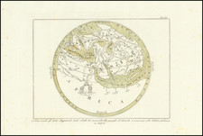
Notable improvements to Plancius' map include the discoveries of the voyages of Willem Barents (1594-1597) in the Russian Arctic, namely the correct depiction of Novaya Zemlya as an island, with an open sea lying between it and the North Pole. Both the Arctic and Antarctic Circles are detailed in insets towards the lower corners of the map.
The map was originally issued in 1608. The Le Maire Straits that run to the east of the Tierra del Fuego, discovered by Jacob Le Maire and Willem Schouten in 1616, were added to the plate around 1621. Thereafter, the plate was sold to Jan Jansson, who used the map in only a few early editions of his atlas. Eventually, the map was heavily reworked and reissued by Moses Pitt in the 1680s.
Differences between the present map and Blaeu's 1606 world map
Despite its initial resemblance, the present map has significant differences when compared to Blaeu's 1606 map. These are largely confined to captions in the Arctic and on Terra Australis, but those textual choices provide important insight into van den Keere's editorial outlook. In general, the additions evidence van den Keere's stronger focus on recent and potential exploration at the edges of the world. Where Blaeu left blank areas, van den Keere has compiled notes from other sources to explain what might exist in these unmapped locations. These include rumors from Spanish and Portuguese sources (in the Pacific), as well as more detailed notes on English and Dutch exploration in the Arctic.
Additions and differences include:
In the vicinity of present-day Australia, van den Keere has added, “Maletur regnum scatens aromatibus” [A kingdom overflowing with spices]. Maletur, and the nearby Beach and Lucach are toponyms in Marco Polo’s Travels. However, its re-inclusion on this map raises the possibility that van den Keere was reacting to news of Willem Janszoon's 1605-06 voyage to Australia.
Notes on Terra Australis more generally (from left to right):
Hanc continentem Australem nonulli Magellanicam regionem abeius inventore nuncupant.
Hae regiones cuidam Hispano apparuerunt, cum disiectus a classe in hoc Australi vagaretur Oceano.
Psittacorum regio sic a Lusitanis appellate ob incredibilem earum avium ibidem magnitudinem.
Promontorium Terrae Australis distans 450 Lucas a Capite Bone Spei & 600 a promontorio S. Augustini.
Inter S. Laurenty & Los Romeros insulas vehemens admodum est versus ortum et occasum fluxus et refluxus maris.
To the east of Tierra del Fuego:
Navigium ex corijs quo accolae Freti Magellanici utuntur. [Borrowed from Jodocus Hondius's 1606 map of the Americas.]
In the Arctic (from left to right):
Anian Fretum et Fretum Joannis Davis latitudine 60. grad. e region insularum Orcadum, forte unu et idem est; plurimi enim multis argumentis contendu oram litoralem Americae Boream versus eousque protendi donec, in modum insulae cum terra Laboratorjs aut Groenlandiae coniungatur. Quad an verum sit saepius, sed frustra, quaesitum est proper ventorum asperos et impetuo sas turbines et maris fremitus terrificos, moutes glacie concretos planeque horendos.
Ulterius Septentrionem versus America omnio est incognita sitne aqua vel terra hoc loco incertum est plurimi tam ex rerum cicumstantiis, comjectant Americam ab hac parte Septentrionali mari succinctam.
Fretum hoc Davis, ab inventore Anglo nomen habet qui an. 1585. 86. et 87. hujus littora perlegit transitum illac in Chinam Scrutando.
Terram hanc e regione Finmarchiae 72 grad. positam detexit Hugo Willoughbeus Eques Anglus anno 1553.
Terra haec abe inventore Anglo nomen sortita est S, Hugo Willoughbes lant.
Nova Zemla Iustrati caepit faeliciter an. 1594. et 95. nominee Illustriss Ordinum foederatarum Infer. Germaniae Regionum, quo aditus ad Chinam Reg. quaerebatur: sed eventus nondum ex animi sententia votis successit.
Incertus admodum est hic Septentrionalis Asiae tractus nos tamen alios imitantes posuim ne imperitiores hic aliquid deesse putarent: donce certius quoddam exedt.
In western North America:
Harum Regionum Indiginae more Tartarorum catervatim in tentoriis habitant, civitates nullas habentes. [In the manner of the Tartars, these indigenous peoples dwell in battalions in tents, having no states.]
Stylistically, the map is skillfully derived from Willem Blaeu's single page map of 1608, but features alterations to the cartouches and decorative embellishments. The panels that run along all sides of the map are rich with allegorical adornment. Across the top are vignettes of the known solar system, including:
- Luna (the Moon),
- Mercurius (Mercury),
- Venus, Sol (the Sun),
- Mars,
- Jupiter
- Saturnus (Saturn).
The panel to the left depicts the four earthly elements:
- Igis (Fire),
- Aer (Air),
- Aqua (Water)
- Terra (Land).
The panel to the right of the map depicts the four seasons:
- Ver (Spring),
- Aestus (Summer),
- Autumnus (Fall)
- Hyems (Winter).
The panel that runs along the bottom of the map features the Seven Ancient Wonders of the World;
- Murus Babyloniae (The Hanging Gardens of Babylon, Nineveh, Iraq),
- Colossus (Colossus of Rhodes, Greece),
- Pyramides (the Great Pyramids of Gizeh, Egypt),
- Mausoleum (Mausoleum of Halicarnassus, Bodrum, Turkey),
- Dianae Templum (Temple of Diana, or Athena, Izmir, Turkey),
- Jupiter Olympicus (State Statue of Jupiter, or Zeus, Olympia, Greece)
- Pharos (The Great Lighthouse of Alexandria, Egypt).
Cartographically, the map is drawn from Petrus Plancius's wall map of 1592. The map incorporates some of the classic cartographic misconceptions of the period, including an elongated Northwest Coast of America, a massive mysterious southern continent (Antarctica) with a very narrow strait between it and South America, as well as an incomplete New Guinea that is attached to the southern continent.
The map features a lengthy notation to the left and right of the large cartouche titled 'America' that discusses whether in fact the apocryphal Anian Straits (at the location of modern-day Alaska) and the Davis Straits actually join to form the Northwest Passage. Related to this aspect, a sprinkling of English names in the Canadian Arctic is included as a result of Martin Frobisher and John Davis's explorations in search of the Northwest Passage in 1576-1587.
Notable improvements to Plancius' map include the discoveries of the voyages of Willem Barents (1594-1597) in the Russian Arctic, notably the correct depiction of Novaya Zemlya as an island, with open sea lying between it and the North Pole. Both the Arctic and Antarctic Circles are detailed in insets towards the lower corners of the map.
The map was originally issued by Pieter van den Keere and dated 1608. The Le Maire Straits that run to the east of the Tierra del Fuego, discovered by Jacob Le Maire and Willem Schouten in 1616, were added to the plate in 1621. Thereafter, the plate was sold to Jan Jansson, who used the map in only a few early editions of his atlas.
All editions are rare on the market.
Jan Janssonius (also known as Johann or Jan Jansson or Janszoon) (1588-1664) was a renowned geographer and publisher of the seventeenth century, when the Dutch dominated map publishing in Europe. Born in Arnhem, Jan was first exposed to the trade via his father, who was also a bookseller and publisher. In 1612, Jan married the daughter of Jodocus Hondius, who was also a prominent mapmaker and seller. Jonssonius’ first maps date from 1616.
In the 1630s, Janssonius worked with his brother-in-law, Henricus Hondius. Their most successful venture was to reissue the Mercator-Hondius atlas. Jodocus Hondius had acquired the plates to the Mercator atlas, first published in 1595, and added 36 additional maps. After Hondius died in 1612, Henricus took over publication; Janssonius joined the venture in 1633. Eventually, the atlas was renamed the Atlas Novus and then the Atlas Major, by which time it had expanded to eleven volumes. Janssonius is also well known for his volume of English county maps, published in 1646.
Janssonius died in Amsterdam in 1664. His son-in-law, Johannes van Waesbergen, took over his business. Eventually, many of Janssonius’ plates were sold to Gerard Valck and Pieter Schenk, who added their names and continued to reissue the maps.
![[Illuminated World Map -- There is no region of the world which Jesus, like the sun, does not enrich...] Orbis nulla plaga est quam sol non ditet Iesus...](https://storage.googleapis.com/raremaps/img/small/62347.jpg)
![Западное Полушариіе | Восточное Полушаріе [Western Hemisphere | Eastern Hemisphere]](https://storage.googleapis.com/raremaps/img/small/82868.jpg)