|
||

|

|
|

|
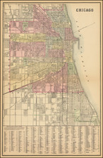
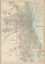
An Unusual Map of Chicago
Unusual birdseye view style map of Chicago, published by Rand McNally & Company, with promotional information and a plat on the verso promoting City Heights.
The map focuses on major streets and transit lines, highlighting "The City Heights" area with a promotional tract at the bottom left and a plat of City Heights on the verso.
In addition to the plat, images of 7 house styles being constructed in the Heights is given, promoted by Thomas P. Keefe.
By the early 1890s, d Keefe owned at least 317 acres in the town of Jefferson (present-day Jefferson Park). He invested heavily, adding six-foot sidewalks, street-curbs, and graded and macadamized streets. Chicago’s City Heights, described by the map as “containing some of the very best residence property in the city,” is called “the greatest opportunity ever opened up and offered in Chicago” and is called “the New Eldorado.” Keefe advises that one can “make some money” or “get a beautiful residence” “for a few hundred dollars.”
The verso features a plat of a section of City Heights. Railroads, trains, and a proposed cable car line are depicted, and illustrated below are various residences, churches, and schools in City Heights. Text from Keefe reads: “Some people are born rich and others achieve riches, and still others have riches thrust on them. The latter are those who are now buying property at the City Heights at the present prices. I cannot afford to hold all the property. I must let go of some of it and try and get the value for the rest.”
Rarity
The map is apparently unrecorded.
Rand McNally & Co. is a large American map and navigation company best known for its annual atlases. The company got its start in 1856, when William Rand opened a print shop in Chicago. He was joined in 1858 by a new employee, Andrew McNally. Together, the men established their namesake company in 1868. Originally, the company was intended to print the tickets and timetables for the trains running to and through Chicago; their first railway guide was published in 1869.
By 1870, they had shifted from just printing to publishing directories, travel guides, and newspapers. Their first map appeared in 1872 in a railway guide. The map was produced using a new wax engraving method, a cheaper process that gave the company an edge.
By 1880 Rand McNally had entered the education market with globes, wall maps, and geography texts for students. In 1923, Rand McNally published the first Goode’s World Atlas, named after its editor, Dr. J. Paul Goode. For generations afterward, this would be the standard classroom atlas.
In 1899, William Rand left the company, but McNally and his family remained, controlling the company for over a century. In 1904, they published their first road map intended for automobiles and by 1907 were publishing Photo-Auto Guides, which combined photography and mapping to help drivers. In 1924, they produced the Auto Chum, a precursor to their famous road atlases. Rand McNally would remain the leader in road maps and atlases throughout the twentieth century.
In 1937, Rand McNally opened its first store in New York City. Ever on the frontier of technology, Rand McNally pioneered the scribing process for printing tickets in 1958 and printed their first full-color road atlas in 1960. Arthur Robinson developed his now-famous projection of Rand McNally in 1969. By the 1980s, the company was exploring digital reproduction and digital databases of maps for truckers. In the 1990s, they lead the charge to develop trip-planning software and websites. Today, most of its products are available online or in a digital format, including maps for tablets and phones.
![[ Chicago Suburbs -- Palos Hills ] All Roads Center on Palos Vista. A Nature-Molded](https://storage.googleapis.com/raremaps/img/small/101839.jpg)