|
||

|

|
|

|
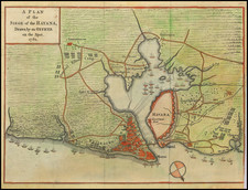
A Rare Early Allegorical Map of Cuba
A Cartographical Improvisation
Repurposing a Map of Drake's 1585 Exploits in Cartagena to Illustrate his Final Foray in Cuba in 1595
This very rare map, printed in Germany in 1596, purports to illustrate Sir Francis Drake's final actions in Cuba. While Drake considered attacking the town in 1586, he actually tried (and failed) to capture the fleets wintering in the by-then highly fortified harbor of Havana during his Caribbean foray with Sir John Hawkins in 1594-1595. The importance of Havana to the Spanish Atlantic trade was well known to Hawkins as early as 1564, when he described it as "a habor whereunto all the fleets of the Spaniards come, and do their tary to have one the company of another."
The map was issued to illustrate a 1596 German-language volume of the Historicae Relationis Continvatio. Warhafftige Beschreibunge aller fürnemmen vnd gedenckwürdigen historien, an early German news publication reporting on recent voyages and world events. It was intended to illustrate a few scattered text sections in the Historicae Relationis Continvatio reporting on Drake's final American voyage, which ended in the explorer's death.
This map of Cuba and Havana, albeit fanciful, is perhaps the earliest surviving printed view of the town.
What makes the present map especially fascinating is how the anonymous mapmaker decided to improvise his map of Cuba by repurposing Baptista Boazio's 1588 map of Cartagena. The latter map was drawn to illustrate Drake's earlier 1585-1586 Caribbean voyage. By changing several details, such as renaming the rather amorphus landmass surrounding "Cuba" to represent the entire eastern seaboard of North America from New France in the north to Florida, New Spain and Peru in the south, the mapmaker was able to fashion an island-like piece of land that might reasonably be seen as shaped something like Cuba. Boazio's original Cartagena map (Civitas Carthagena in Indiae occidentalis continente sita), was one of four charts drawn to accompany Walter Bigges' Expeditio Francisci Draki quitis Angli in Indias occidentales, the report of Drake's 1585 expedition against Spain, published in 1588. As in so many situations where necessity is the mother of invention, it would seem that the mapmaker in Germany, who required an engraving to illustrate the text references to Drake's latest 1595 voyage, opted for an easy expedient: a reworking Boazio's earlier Drake map of Cartagena to show the latest news of Drake's latest Caribbean foray. In retrospect, the use of one of Boazio's views of plans to continue the accoount of Drake's latest exploits, as illustrated in maps, seems quite logical. Certainly, Boazio's "view plans are probably the most interesting published graphic works pertaining to Drake and his career" - H. P. Kraus.
Besides the renaming of land masses, there are several notable changes to the Cartagena map in its transformation into a Cuba map.
The biggest change is the widening of the river in the left side of the original map in order to create an illusion of an island in the Caribbean Sea. The disproporationately large image of the island of Cuba and the harbor of Havana are thus emphasized in the foreground. Marching troops, houses, animals, trees and plantations or farms are visible on the island. A sea monster has been added here that is not present in the original Cartagena map, and the lizard-like creature from the Cartagena map is here named a Crocodile!
And while one authority goes so far as to describe this map as a "total fake" due to its Cartagena source map (see Emilio Cueto reference below), an early director of the Biblioteca Nacional in Havana has this map as the first chronological entry in his study of Cuban maps (see Figarola-Caneda, also referenced below).
Bibliographical Condundrum Solved?
The actual source publication for the present map is the Historicae Relationis Continvatio, a serial publication issued twice a year to coincide with the Frankfurt book fair in spring and autumn. These works were written by Conrad Lautenbach (1534-95) under the pseudonynm Jacobus Francus and the series was continued in the same name after Lautenbach's death, with later volumes attributed to Conrad Memmius. A fully digitized version of the 1596 volume of the work is available online from a German library, clearly showing the Die Grosse Insel Cuba map as integral to that publication.
However, this map is also known to accompany at least one copy of a very rare German language pamphlet on Drake: Franciscus Dracus Redivivus. (Amsterdam or Cologne, 1596).
The full title of that work is:
Franciscus Dracus Redivivus: Das ist, kurze Beschreibung, aller vornehmbsten Reysen, Schiffarten vnnd Wasserschlachten, so der weitberümbte englische Admiral, Franciscus Dracus, welcher inn zwey Jahren vnd zehen Monaten orbem mundi beschiffet, hin vnd wider bey Pleymeuten, Cartsag: S. Domingo. August: Florida vnd der Insul Cuba, in seinem Leben glücklich gehalten vnd vollbracht. : Item von der jetzigen engelischen Admiraln vnnd Schiffobersten bey Calis Malis verrichten vnd Abzug, vnd was sie noch weiter daselbsten herumb biss dato vorhaben, [et]c. : Alles in drey Kupfferstück ordentlich vorgebildet, vnd durch Ziffern erkläret, [et]c.
[English translation:]
Franciscus Dracus Redivivus: That is, a short description of all the most important ships, types of ships and sea battles, according to the well-known English admiral, Franciscus Dracus, who in two years and ten months sailed orbem mundi, back and forth by pley packs, Cartsag: S. Domingo. August: Florida and the island of Cuba, happily accomplished in his life: Actions by the present English admirals and ship captains at Cadiz and deduction, and what they are still planning to do there, etc. : Everything properly represented in three pieces of copper, and explained by numbers, etc.
That extremeley rare little book recounts the exploits of Drake, beginning with his voyage from Plymouth in November 1585, including time in Cartagena, Santa Domingo, St. Augustine, Florida and Cuba. On this voyage, Sir Francis Drake struck first at Santiago (Cape Verde Islands), then arrived in Santo Domingo on January 1586, where he ransomed the city. He proceeded next to Cartagena, which he attacked on February 19, 1586. Drake then proceeded to the north, in search of Sir Walter Raleigh's Roanoke Colony in the modern day Carolinas, which at the time was in an area then called Nova Francia. Drake's expedition first reached Cuba in April, 1586, before proceeding northward, coasting Florida in May 1586, where Drake attacked the Spanish fort and later the settlement of St. Augustine, seizing among other things a chest containing 2,000 gold ducats. The text also summarizes Drake's final 1594-1595 voyage with John Hawkins, as well as the combined Anglo-Dutch attack on Cadiz in 1596.
It is an open bibliographical problem whether the Franciscus Dracus Redivivus was actually issued with the present map of Cuba. Evidence suggests that the map may not have been issued in that work, or perhaps only a few copies were ever accompanied by the map.
Here follows a chronology of a biblio-cartographical puzzle:
1. The 19th-century bibliographer, P. A. Tiele described a copy of the Franciscus Dracus Redivivus that lacked all the plates in his 1867 bibliography on early Dutch voyagers (included in the bibliography due to the section in the pamphlet on the Anglo-Dutch attack on Cadiz in 1596). Tiele's detailed entry on the missing plates and maps is based on his careful reading of the text (which seems to refer to the plates). According to Tiele, pages 8-11 contain an account of Drake's final expedition in 1594 with John Hawkins, "to serve as an explanation of the first eight numbered figures of the 3rd (?) plate." This statement by Tiele may be the source of later assertions that the present Cuba map was originally issued with the Franciscus Dracus Redivivus, as the map does include numbered figures 1-10.
2. In his 1910 study of rare Cuban maps in the British Museum the Director of the Biblioteca Nacional de la Habana, Domingo Figarola-Caneda, described this map as entry no. 1, with an incorrect inferred date of [Augsburg? 1560?].
3. The 1927 Annual Report of the John Carter Brown Library at Brown University (page 5), clearly indicates that the Grosse Insel Cuba map was something the JCB purchased later to "complete" one of their "imperfect" copies of the pamphlet. It is interesting to note here that the JCB has an additional copy of the pamphlet which still lacks all the plates. A careful look at the digitized version of the copy "with the plates" in the John Carter Brown Library clearly shows the map is not attached to the stitching or binding of the text leaves. This digitized copy also includes two engraved portraits that do not, properly speaking, belong with the book. Here follows the rather amusing passage from the 1927 Annual Report:
The acquisition of books continues to be the adventure that the collecting of treasure has always been to those who give themselves to that thrilling employment. Just when it seems that everything worth while has been secured or has become no longer available for purchase, one of our friends among the booksellers turns up something of unusual interest. Or, when we have despaired of finding a much desired item - for example the fabulously rare Drake portrait needed for the Franciscus Dracus Redivivus, printed in German in 1596 - a Parisian printseller appears on a casual visit and when facetiously questioned, reaches into his portfolio and answers the wild surmise in our eyes by drawing out the one print in all the world most essential to our happiness at that moment. The portrait was from the print collection of Louis Philippe, and the printseller, properly rewarded, is now searching for the Cavendish portrait, the Grosse Insel Cuba map and the Armada print needed to make our copy of the book, a great rarity in itself, the only one known to possess its plates besides that in the British Museum.
4. In a 1998 scholarly article on Cuban cartography, Emilio Cueto mentions that the Staatsbibliothek Bamberg dates the map to 1600, but he fails to indicate the source publication for the map. Cueto also speculates as to why this so-called "hoax" map was made:
In spite of the title, however, I discovered it is a total fake: in fact, it is a map by Boazio of Cartagena, Colombia, published at the time of Drake's West Indian voyage (1586). The resons for this hoax are unknown; perhaps a German editor needed a map of Cuba to illustrate some book and, instead of getting a real Cuba map, thought he would get away with this substitution. Or perhaps he found the right map in time, and this one never circulated widely (which may explain its scarcity).
5. A 2008 book by Alejandro de la Fuente, Havana and the Atlantic in the Sixteenth Century (Chapel Hill: University of North Carolina Press, 2008) reproduces the map on page 68, describing it thusly:
This distorted view of Havana as a major port city was inspired by the drawings of Baptista Boazio about Francis Drake's expedition to America. "Die Grosse Insel Cuba mit der umbligen der lantschaft" (The Great Island of Cuba and Neighboring Territories), Augsburg (ca. 1580s); courtesy of Biblioteca Nacional "José Martí," Havana.
6. In 2022 this firm, in describing the present example of the map - only the second copy known to have changed hands in recent years - here documents the only confirmed source publication of the map as being the 1596 volume of the Historicae Relationis Continvatio, this based on the complete digitized volume posted online by the Universitats- Und Landesbibliothek Sachsen-Anhalt at the Martin Luther Universitat Halle-Wittenberg.
While it is possible that our Cuba map was also issued with the Franciscus Dracus Redivivus, without additional "complete" copies of that rare pamphlet, containing all of the maps, it would seem to be impossible to settle the question definitively.
Rarity
The map is of the utmost rarity and we know of only one other copy to have changed hands in modern times, a copy handled by this firm. We can also confirm only three copies in institutional confines: that in the John Carter Brown Library (described above). And while it is not clear whether the example from the Biblioteca Nacional "José Martí" in Havana reproduced by Alejandro de la Fuente in his recent book is an original or a facsimile, Emilio Cueto cites two additional institutional holdings:
I have located two copies of this map, one in the British Library, identified as "1560?," and "Augsburg?", the other in the Staatsbibliothek Bamberg, where it is identified as "1600." This map is always included in all Cuban repertories (Figarola 1, Massip 90, Ríos 96).
For the digitized copy of Franciscus Dracus Redivivus (1596) at the John Carter Brown Library (showing the map as completely detached from that text): https://archive.org/details/franciscusdracus00cave/page/n21/mode/2up
References to the map only: Figarola-Caneda, Domingo. Cartografía Cubana del British Museum: Catálogo cronológico de cartas, planos y mapas de los siglos XVI al XIX: entry 1. Cueto, Emilio, Cuban Cartography, 1500-1898 [in:] Cuban Studies. Vol. 27 (1998): entry 1K (page 161). De la Fuente, Alejandro. Havana and the Atlantic in the Sixteenth Century (2008), page 68 (illustrates a copy of the Die Grosse Insel Cuba map "courtesy of" the Biblioteca Nacional "José Martí," Havana, dating it from Augsburg, ca. 1580s.
For descriptions of Franciscus Dracus Redivivus, cf. European Americana 596/47. Tiele, P. A. Mémoire Bibliographique sur les Journaux Navigateurs Néerlandais, 279 (cites copy missing all plates and maps: "Les planches manquent a notre exemplaire")
![Isla de Cuba con arreglo a la nueva division territorial [and] Isla de Puerto-Rico](https://storage.googleapis.com/raremaps/img/small/95148.jpg)
![Island of Cuba (Spanish) and Jamaica (British) [also South Florida, Bahamas and Cayman Islands]](https://storage.googleapis.com/raremaps/img/small/98323.jpg)