|
||

|

|
|

|
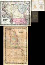
Westward Across the Plains. Previously Unrecorded First State.
An exceptional separately-issued wall map of northern Plains showing the progress of railroad building during the pivotal 1860s. The map was produced for the Chicago & Northwestern Railway and lithographed by Edward Mendel of Chicago.
While nominally about the Chicago & Northwestern Railway, this map also serves to document the transit of the Union Pacific Railroad across the plains, as well as several other important routes that were developed during the 1860s. This is an important depiction of the Union Pacific before it had progressed into present-day Wyoming (then Dakota Territory).
The map bears comparison to the 1868-69 Dodge Map of the Union Pacific, also an exceptional rarity. The two maps inform each other, with this map showing how the Union Pacific joined with the rest of the rail network to its east.
This map covers Nebraska, Iowa, and Wisconsin, as well as much of Illinois, Dakota Territory, and Minnesota. Important sections of Colorado (to "Denver City") and the Upper Peninsula are also depicted.
The map was intended to communicate the utility of the Chicago & Northwestern, which was reinforced in turn by the importance of the railroads to which it connected. The route from Chicago to Council Bluffs and thence Omaha was the primary feeder route for the Union Pacific. After the completion of the Union Pacific in 1869, the Chicago & Northwestern replaced this map with maps that focused on the whole United States or the whole of the West when trying to communicate the importance of its feeder route. The C & NW remained a dominant player in regional shipping throughout the Upper Midwest well into the 20th century before being acquired by the Union Pacific.
States & Rarity
The present map is a previously unrecorded first state of the map. While the other examples that we have seen show the completion of the Union Pacific through Dakota Territory (i.e., Wyoming) the railroad has not proceeded that far on this map.
Modelski (369) identifies the map as having been published in 1862. This is certainly not the case with the example that the Library of Congress now displays digitally, as the progress of the U.P.R.R. and other features make 1869 a more appropriate date.
The most important difference between the present example and the others we have seen is the progress of the U.P.R.R. In the present map "Cheyenne Pass" has seemingly been discovered by General Dodge, which occurred in 1865, but the railroad has not progressed beyond Julesburg, which was reached in June 1867. However, the title block has also been moved in the second edition and other changes to railroad completion have been made in the second state.
- Present example. Circa 1867.
- Library of Congress; Boston Public Library. Circa 1869.
Unidentified: Yale; Pennsylvania State.
We located no examples in OldMaps.com nor RBH. We have not traced another example having been on the market.
This map belongs to a class of separately-issued map of the Plains that also includes such rarities as the Military District maps of Nebraska and the Dakotas and the previously-mentioned Dodge map of the Union Pacific.
![North America Sheet IX Parts of Missouri, Illinois and Indiana [and the Sioux District]](https://storage.googleapis.com/raremaps/img/small/84193.jpg)
![[ Ohio - Seven Ranges ] Plat of the Seven Ranges of Townships being Part of the Territory of the United States N.W. of the River Ohio which by a late act of Congress are directed to be sold . . . 1785](https://storage.googleapis.com/raremaps/img/small/82394.jpg)