|
||

|

|
|

|
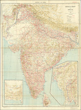
Rudolf Swoboda the Younger's Hand-Annotated Map of India. Showing the Journey Undertaken During his Royal Commission to Sketch Queen Victoria's Subjects.
Map annotated by Rudolf Swoboda the Younger showing the route taken during one of the most important commissions of his career, his 1886 journey to India to paint the people of western India.
Rudolf Swoboda the Younger was one of the most important late-18th-century European painters of India and its people. A noted painter of Orientalist subjects, he found favor with Queen Victoria in 1886 at the age of twenty-seven when he painted Indian artisans that had traveled to Windsor Castle for the Golden Jubilee preparations. The Queen was so pleased that she immediately sent him to India to provide £300 pounds worth of sketches with the following orders:
The Sketches Her Majesty wishes to have – are of the various types of the different nationalities. They should consist of heads of the same size as those already done for The Queen, and also small full lengths, as well as sketches of landscapes, buildings, and other scenes. (Quoted by the Royal Collection Trust)
This map, published at Stanford's Map Establishment in London in 1885, was evidently used on this journey. In the upper left, we see the annotations in a mix of German and English for a train journey between two locations in the vicinity of Islamabad. More interestingly, we see that Swoboda underlined various cities between Mumbai and Rawalpindi.
These underlined cities correspond perfectly to many of the places visited by Swoboda on his journey. Swoboda evidently arrived in Bombay, then traveled north to Gujarat to sketch Sir Pratap Singh of Idar, one of the two princes who Queen Victoria had expressly asked to be painted. From there, Swoboda traveled to Lahore to paint soldiers, Islamabad to paint priests, and Kashmir to paint a boatman. All these places and many more are underlined on the map.
Swoboda's sketches were received in England with the utmost praise. Queen Victoria said of them that they were: "such lovely heads… beautiful things." Sir Howard Elphinstone, Governor to Prince Arthur, described them as "They are very clever indeed, most characteristic of the different types, & drawn with wonderful vigour."
Edward Stanford (1827-1904) was a prominent British mapmaker and publisher. A native of Holborn in the heart of London, Edward was apprenticed to a printer and stationer at the age of 14. After his first master died, he worked with several others, including Trelawny W. Saunders of Charing Cross. Saunders oversaw young Edward’s early career, ensuring that he became a Fellow of the Royal Geographical Society. Associations with the Society eventually brought Sanders much business and gave him a reputation as a publisher of explorers. As testament to this reputation, the Stanford Range in British Columbia was named for him by John Palliser.
Stanford briefly partnered with Saunders in 1852 before striking out on his own in 1853. He was an agent for the Ordnance Survey, the Admiralty, the Geological Survey, the Trigonometrical Survey of India, and the India Office. He also controlled the maps of the Society for the Diffusion of Useful Knowledge, another lucrative source of income. In 1857, Stanford founded his namesake Geographical Establishment, with Saunders and A. K. Johnston as engravers. Thereafter, Stanford was known for his “library maps”, particularly those of Africa and Asia.
Addresses and Years of Operation:
- 6 Charing Cross, London (1848): Edward Stanford's initial place of employment at Trelawney Saunders' shop.
- 7 and 8 Charing Cross, London (1853): Stanford expanded his shop to these addresses.
- 55 Charing Cross, London (1873): The shop moved to this larger location.
- 12-14 Long Acre, London (1873): Site of the new print works and current flagship store.
- 7 Mercer Walk, London (2019): Stanfords moved to this address, continuing its legacy.
Stanford's work with Chief Cartographer John Bolton, including the 1858 Library Map of Europe, positioned the company as a leader in quality cartography during a time of exploration and colonialism. Their 1862 Library Map of London earned acclaim from the Royal Geographical Society. With the business thriving, Stanford purchased Staunton & Son in 1877 and, upon retiring in 1885, handed over the reins to his son, Edward Stanford II.
As sole agents for Ordnance Survey Maps, the company's influence and reputation grew, culminating in the Stanford’s London Atlas Of Universal Geography, which was presented to Queen Victoria in 1887. The transition into the 20th century saw further integration of retail, print, and cartographic operations at Long Acre.
During World War I, Stanford's became an essential publisher for the War Office. Edward Fraser Stanford took over in 1917, steering the company through the interwar period and innovations, such as the world’s smallest maps in 1922 and the Daily Mail Motor Road Map in 1926.
Withstanding a bombing in WWII, the company continued under the stewardship of John Keith Stanford and was sold to George Philip & Son in 1947. As it adapted to the digital age, Stanfords received the Ordnance Survey Premier Partner status in 2007 and ventured into online mapping and data services.
Stanfords, now an icon for travellers and explorers, has maintained its cultural relevance and retail success well into the 21st century, underpinned by a legacy of entrepreneurial spirit and commitment to cartographic excellence.
![[Puducherry-- Hand Drawn Map] Plan de la Ville de Pondichery. Legende des Rues de la ville blanche et de la ville noire de Pondichery avec les numeros d'ordre correspondant a ceux du plan que Mr. le Gouvernor a approuve le Mai 1856](https://storage.googleapis.com/raremaps/img/small/58607.jpg)
![(Puducherry) Plan De La Ville De Pondicheri Dedie A La Memoire De Mr. Dupleix . . . 1748 . . . [Plan of the City of Pondicherry Dedicated to the Memory of Mr. Dupleix... 1748...]](https://storage.googleapis.com/raremaps/img/small/95813.jpg)