


|
||

|

|
|

|
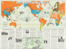
Attractive large folding map of the world by James Wyld, who was one of the best mapmakers of his day.
The map is undated but almost certainly comes from the period around 1858. The cartography in the United States suggests that the map is actually earlier: The Gadsden Purchase (1853-54) hasn't yet occurred. A very large but undefined Texas is part of the United States (post-1845). California is shown as part of the United States but without any internal division beyond the old Alta California (post-1848).
Despite the retrograde information in the United States, the map has been altered (changes to the plate are evident) to show "British Columbia," which was known as "New Caledonia" until 1858.
The map shows the "Sea of Corea" and "Str. of Corea".
The treatment of Africa shows there is still much about the interior that was unknown to European cartographers.
These sheets also appeared as separate maps in Wyld's larger folio atlases of the time.
James Wyld Sr. (1790-1836) was a British cartographer and one of Europe’s leading mapmakers. He made many contributions to cartography, including the introduction of lithography into map printing in 1812.
William Faden, another celebrated cartographer, passed down his mapmaking business to Wyld in 1823. The quality and quantity of Faden’s maps, combined with Wyld’s considerable skill, brought Wyld great prestige.
Wyld was named geographer to Kings George IV and William IV, as well as HRH the Duke of York. In 1825, he was elected an Associate of the Institution of Civil Engineers. He was one of the founding members of the Royal Geographical Society in 1830. Also in 1830, his son, James Wyld Jr., took over his publishing house. Wyld Sr. died of overwork on October 14, 1836.
James Wyld Jr. (1812-87) was a renowned cartographer in his own right and he successfully carried on his father’s business. He gained the title of Geographer to the Queen and H.R.H. Prince Albert. Punch (1850) described him in humorous cartographic terms, “If Mr. Wyld’s brain should be ever discovered (we will be bound he has a Map of it inside his hat), we should like to have a peep at it, for we have a suspicion that the two hemispheres must be printed, varnished, and glazed, exactly like a pair of globes.”
![Western Hemisphere | Eastern Hemisphere [2 sheets]](https://storage.googleapis.com/raremaps/img/small/85676.jpg)
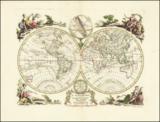
![[Heightened in Gold] Nova Totius Terrarum Orbis Geographica Ac Hydrographica Tabula Autore N I Piscator . . . 1652](https://storage.googleapis.com/raremaps/img/small/82696.jpg)
