This item has been sold, but you can enter your email address to be notified if another example becomes available.


|
||

|

|
|

|
Stock# 85341
Description
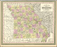
Exceptionally detailed separate railroad map of Missouri, issued by the State of Missouri and printed by Woodward & Tiernan in St. Louis in 1914.
The map lists dozens of color-coded railroad lines that criss-cross the state. There are insets of more detailed mappings of the areas around Kansas City and St. Louis.
The map provides a wonderful view of Missouri's railroads when they were essentially at the apex of their coverage and importance to the state.
Condition Description
Folding map with original gilt-lettered green cloth folder.