|
||

|

|
|

|
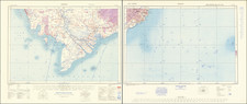
French Map of The Gulf of Tonkin at the End of the Sino-French War.
Fine, large map of the Tonkin Delta region, published in France following the close of the Sino-French war in June of 1885.
The map was produced by the Depot de la Marine (the French Navy) following the surveys executed by the officers of the expeditionary forces. It shows the region in fantastic detail, with rivers, topography, roads, and much more shown. Cities are shown with a rough layout, for example the walls of Hanoi and the neighborhoods of Haiphong are shown.
This map was made at the close of the Sino-French War, a war that improved French control over North Vietnam. The French had captured Hanoi in 1882 and expanded their north Vietnamese holdings, but suffered insurrection from the Chinese-supported Black Flags. An initial Treaty between France and China with concessions on both sides was signed in May of 1884, but the discovery and destruction of a Chinese column encamped in French territory led to an all-out war between the two powers. Battles were fought in China, and the French managed to win a difficult war. However, at the end of the war, the French attempted to overextend their troops and push further north, which led to domestic uproar and the collapse of the Jules Ferry government.
Rarity
OCLC lists three examples, at the BNF, Parisian Museum of Natural History, and University of Chicago.

![[ First Plan of Bangkok ] Sketch of the Town of Bang-Kok, by a Native.](https://storage.googleapis.com/raremaps/img/small/74889.jpg)