


|
||

|

|
|

|
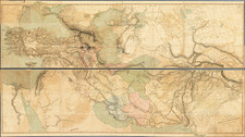
Finel old color example of the Covens & Mortier edition of Philippe de la Rue's map of the Holy Land.
Based upon the writings of the Old Testament (Genesis, Exodus, Leviticus, Numbers and Deuteronomy), the map shows Holy Land at the time of Abraham and Moses, including the path traveled by Moses and the Israelites from Egypt, across the Red Sea and ultimately to the banks of the Jordan River, which were crossed by the Israelites by Joshua, with Moses remaining on the east side of the Jordan, according to the Old Testament.
The smaller inset map hsows the path traveled by Abraham to Canaan, according to the Book of Genesis.
Covens & Mortier was one of the largest and most successful publishing firms in Dutch history and continued in business for over a century. Pierre Mortier the Elder (1661-1711) had obtained a privilege in 1690 to distribute the works of French geographers in the Netherlands. After his widow continued the business for several years, Cornelis (1699-1783) took over in 1719.
In 1721, Mortier forged a partnership with Johannes Covens (1697-1774), who had recently married Cornelis’ sister. They published under the joint name of Covens & Mortier. In 1774, upon the death of his father, Johannes Covens II (1722-1794) took over his father’s share. In 1778, the company changed its name to J. Covens & Zoon, or J. Covens & Son.
Covens II’s son, Cornelis (1764-1825), later inherited the business and brought Petrus Mortier IV back into the fold. Petrus was the great-grandson of Petrus Mortier I. From 1794, the business was called Mortier, Covens & Zoon, or Mortier, Covens, & Son.
The business specialized in publishing French geographers including Deslisle, Jaillot, Janssonius, and Sanson. They also published atlases, for example a 1725 reissue of Frederik de Wit’s Atlas Major and an atlas, with additions, from the works of Guillaume Delisle. There were also Covens & Mortier pocket atlases and town atlases. The company profited from acquiring plates from other geographers as well. For example, the purchased Pieter van der Aa’s plates in 1730. Finally, they also compiled a few maps in house. At their height, they had the largest collection of geographic prints ever assembled in Amsterdam.

![[ Biblical Names for Palestine ]. Carte de La Palestine Ancienne et Moderne avec le Sud du Liban et de l'Anti-Liban et les régions situées à l'est du Jourdain et de la Mer Morte, pour servir à l'étude de la Bible par A. Legendre [Map of Ancient and Modern Palestine with Southern Lebanon and Anti-Lebanon and the regions east of the Jordan and the Dead Sea, for use in the study of the Bible by A. Legendre]](https://storage.googleapis.com/raremaps/img/small/85737.jpg)