|
||

|

|
|

|
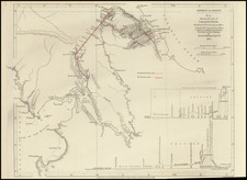
Published During the War of the Spanish Succession, Showing an Important Spanish Port in the Americas.
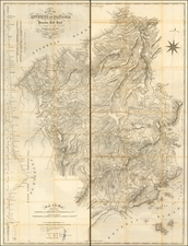
Original, antique map depicting the key harbor of Portobello, Panama, published by Pierre Mortier in Amsterdam in 1702. This harbor was amongst the most important locations in the Spanish Empire, as it was a major transshipment point for the Spanish treasure galleons before they made the journey from the New World to Spain
Located on the Caribbean side of the Panamanian isthmus, since 1597, it had been the most important loading point on the Atlantic side for Peruvian silver and gold on its way to Spain. Ships transported the silver up the Pacific coast from Callao to Panama City, and then overland to Portobello by horse and mule train. While a small town, it hosted a very important annual market and, as shown, it was guarded by two large forts. 'The Kings Stabels' marks the point where the treasure was unloaded. Engish pirates had long preyed upon Portobello. Captain Willam Parker successfully sacked the town in 1601, followed three generations later by the legendary pirate Sir Henry Morgan, in 1668. The town remained safely in Spanish hands during the War of Spanish Succession but would be successfully taken by Admiral Edward Vernon in 1739.
This map was also published at a key time, during the War of Spanish Succession (1701-13), which essentially pitted the Spanish Bourbons and their French familial allies against Great Britain. The war in the West Indian theater produced a tense atmosphere where English pirates sparred with the Spanish guarda costas, and where Spain's major New World ports remained in a constant state of alert against attack from the British Royal Navy. While Porto Bello was ever attacked during this war, the possibility of conflict ensured that it was at the top of the news and this map would have been of great interest to observers throughout Europe.
The present map sheet appeared in Pierre Mortier's Les forces de 'Europe, Asie, Afrique et Amerique ou description des principales villes, avec leurs fortifications... (Amsterdam in 1702). Pierre Mortier (1661-1711) was a successful Dutch publisher of Huguenot extraction, who specialized in introducing the finest contemporary French cartography to the Netherlands, and the broader European market at large. This map had been early issued by Nicolas De Fer (Paris, 1694-1697), as one of the four American plans in his work (the others being Cartagena, Havana, and Quebec City).
States
At least two states of this map exist, with a second state erasing the pagination "161" in the lower right. This is the first of the two states.
Pierre, or Pieter, Mortier (1661-1711) was a Dutch engraver, son of a French refugee. He was born in Leiden. In 1690 he was granted a privilege to publish French maps in Dutch lands. In 1693 he released the first and accompanying volume of the Neptune Francois. The third followed in 1700. His son, Cornelis (1699-1783), would partner with Johannes Covens I, creating one of the most important map publishing companies of the eighteenth century.