|
||

|

|
|

|
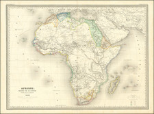
Mapping The Cartographic Myths of Africa -- The Kingdom of Prester John and Source of the Nile
Finely executed map of the central portions of Africa by the prominent Dutch cartographer, Jodocus Hondius.
Hondius' map offers a captivating glimpse into the late 16th and early 17th century understanding of Africa. Crafted with Hondius's characteristic combination of precision and artistic flair, the map offers a fascinating blend of known geographical features, conjecture, and myth, emblematic of the era of exploration in which it was created.
This impressive map is centered around the Kingdom of Prester John, the mythical Christian King and Priest, believed by Europeans to rule over a vast realm in the heartlands of Africa. It reflects the fascination of the period with the legends of Prester John, offering tantalizing hints of the wonders of his empire, in a world where fantasy and reality were still closely intertwined on the geographical stage.
One of the map's most noteworthy features is its depiction of the Nile, which is shown as ending in two large lakes in the southern part of Africa. This representation mirrors the Ptolemaic tradition, perpetuated in maps of Africa into the 17th century, which imagined the Nile's sources as two lakes aligned east to west. While we now know this to be geographically incorrect, this depiction is a significant testament to the prevailing knowledge and theories of the time.
The map also sheds light on the exploration of Africa in the late 16th and early 17th centuries. It delineates the known coastal regions with relative accuracy, reflecting the information gathered by European explorers who had navigated around the African continent. However, the map also reveals the limits of European exploration at the time, with the interior of the continent largely speculative and filled with mythical beasts, mountains, and rivers.
One of the most important geographic enigmas of the Medieval and early modern periods was the kingdom of Prester John. The legend of a Christian Kingdom lost among Muslim lands was popular from the twelfth century and continued long into the seventeenth. Prester John was supposedly descended from one of the three magi. Over time, the utopian kingdom of Prester John came to house a bevy of other fantastical objects, including the Fountain of Youth.
The idea of a Christian King, a Presbyter John, of immense wealth had been circulating since the mid-twelfth century, part of the rumors that swirled around the Crusades. The story received a boost from a mysterious letter sent to the Byzantine Emperor Manuel I. The letter, supposedly written by John, describes his power, faith, and lands. The letter circulated ca. 1165 and survives in nearly 100 medieval manuscript copies. Initially, Europeans thought Prester John’s kingdom was in India, and later in Central Asia. Finally, in the early modern period, the search shifted to Africa, specifically in Christian Ethiopia.
The story and the desire to find the kingdom was ubiquitous across Europe for centuries, losing steam only in the seventeenth century when antiquarians found that the Prester John story had no convincing ties to Ethiopia. Its popularity testifies to the anxieties within the Christian faith during an epoch when Christianity was fighting for survival in the Middle East, and when Christian Europe was often in conflict with Muslims in the Ottoman Empire and was encountering Indigenous peoples, and their religious systems, around the world.
Jodocus Hondius the Elder (1563-1612), or Joost de Hondt, was one of the most prominent geographers and engravers of his time. His work did much to establish Amsterdam as the center of cartographic publishing in the seventeenth century. Born in Wakken but raised in Ghent, the young Jodocus worked as an engraver, instrument maker, and globe maker.
Hondius moved to London in 1584, fleeing religious persecution in Flanders. There, he worked for Richard Hakluyt and Edward Wright, among others. Hondius also engraved the globe gores for Emery Molyneux’s pair of globes in 1592; Wright plotted the coastlines. His engraving and nautical painting skills introduced him to an elite group of geographic knowledge seekers and producers, including the navigators Drake, Thomas Cavendish, and Walter Raleigh, as well as engravers like Theodor De Bry and Augustine Ryther. This network gave Hondius access to manuscript charts and descriptions which he then translated into engraved maps.
In 1593 Hondius returned to Amsterdam, where he lived for the rest of his life. Hondius worked in partnership with Cornelis Claesz, a publisher, and maintained his ties to contacts in Europe and England. For example, from 1605 to 1610, Hondius engraved the plates for John Speed’s Theatre of the Empire of Great Britaine.
One of Hondius’ most successful commercial ventures was the reprinting of Mercator’s atlas. When he acquired the Mercator plates, he added 36 maps, many engraved by him, and released the atlas under Mercator’s name, helping to solidify Mercator’s reputation posthumously. Hondius died in 1612, at only 48 years of age, after which time his son of the same name and another son, Henricus, took over the business, including the reissuing of the Mercator atlas. After 1633, Hondius the Elder’s son-in-law, Johannes Janssonius, was also listed as a co-publisher for the atlas.