


|
||

|

|
|

|
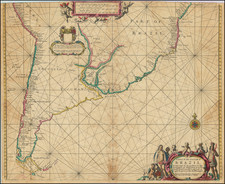
Fine old color example of Hendrick Doncker's revised version of Arnold Colom's rare and highly important sea chart of most of South America, first published circa 1656.
Colom's map is one of the earliest obtainable Dutch Sea Charts to show the Sea Coasts of South America and the rarest of the early charts of South America on the market. The map shows the coastal features of South America south of the Equator, with a large inset of Central America. The chart is executed in the Portolan style, with rhumblines and fine coastal detail for the time period.
For the re-issue, Doncker has added a large inset of the mouth of the Rio de la Plata, including the location of Bones Ayrres (Buenos Aires), complete with a small profile view of the town's waterfront. The town of Ondedondade is shown on the opposite coastline. This is a significant revision and improvement to the treatment in the main map, which is unchanged, although the main map uses the correct Spanish name (Buenos Aires).
The inclusion of the Buenos Aires, with detailed soundings, likely reflects its growing importance as an outlaw trading center in the second half of the 17th Century. The city was originally established by Spanish explorer Pedro de Mendoza in 1536. Following its abandonment and re-establishment in 1580, the settlement grew to become a prominent port city, albeit constrained by the Spanish mercantile laws and the overarching influence of the Viceroyalty of Peru. This period witnessed Buenos Aires evolve from a struggling outpost into a burgeoning center of contraband trade, with its port serving as a nexus for the exchange of goods from both the Spanish colonies and other European powers.
In a historical context, Buenos Aires was significantly disadvantaged by the Spanish Crown's stringent trade laws. These edicts limited direct trade with Spain to only a few authorized ports, most notably the ports attached to the Viceroyalties of New Spain and Peru. However, Buenos Aires' location on the Atlantic coast made it an accessible alternative, leading to an influx of illegal trade. Ships from Portugal, England, and France found it more expedient to conduct business at Buenos Aires, thereby bypassing the costly and lengthy route to authorized ports. As a result, the city developed a thriving, albeit illicit, commerce.
Hendrik Doncker was a prominent bookseller in Amsterdam best known for his sea charts and nautical atlases. He issued his own original charts, which he updated frequently, and also worked with colleagues like Pieter Goos, for example to produce the pilot guide, De Zeespeigel. He died in 1699, after fifty years in business. His plates then passed to Johannes van Keulen.
![Relacion del Viage, que por orden de Su Magestad, y acuerdo de el Real Consejo de Indias, hicieron los Capitanes Bartholome Garcia de Nodal, y Gonzalo de Nodal, Hermanos... Al Descubrimiento del Estrecho Nuevo de San Vicente, que Hoy es Nombrado de Maire, y Reconocimiento del de Magallanes [Bound with, as usual:] ECHEVELAR, Manuel de. J. M. Y J. Instruccion Exacta, y Util de las Derrotas, y Navegaciones, que se Executan en todos tiempos en la America Septentrional, de unos Puertos a otros: con las Advertencias de Sondas, y Notas, Para Ponerlas en Practica. Cadiz. 1753.](https://storage.googleapis.com/raremaps/img/small/89551.jpg)

![[Martin Garcia Island, Argentina] Ilha De Martin Garzia](https://storage.googleapis.com/raremaps/img/small/59597.jpg)