|
||

|

|
|

|
Stock# 85154
Description
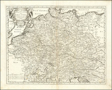
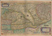
Scarce 18th-century English-language map of Silesia, showing the region on either side of the Oder River.
The map includes the principalities of Glogau, Wolau, Lignitz, Oels, Breslau, Javer, Schweidnitz, Brieg, Oppeln, Neysze Trahenberg Sagan, Carolath, Franckenstein, Ratibor,and Leobshutz. The map shows towns, rivers, mountains, lakes, and other features. The detail is impressive for this relatively small region.
Robert Wilkinson was active in London as a cartographic publisher from 1785 to 1825. He produced a number of nice works, including a General Atlas and a re-issuance of Bowen & Kitchen's English Atlas, along with excellent large-format separate maps.
Condition Description
Original hand-color.
![Thietmarsiae, Holsaticae Regionis Partis Typus Auctore Petro Boeckel [with] Prussia Descriptio ante aliquot annos ab Henrico Zellio ab coque D. Ioanni Clur. civi Gedanesi Ded:](https://storage.googleapis.com/raremaps/img/small/45904.jpg)