|
||

|

|
|

|
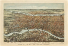
A very nice example of Mathias Albrecht Lotter's edition of Scull & Heap's seminal Philadelphia map.
When first issued in 1752, the famous Scull and Heap plan was intended to promote William Penn's new city on the Delaware River. When the events of the American Revolution began to heat up, illustrations of one of the centers of the revolt, Philadelphia, began to be in great demand in Europe. This demand was soon met by publishers in England, Germany, and France with the reissue of the Scull and Heap map, still the most up-to-date cartographic treatment of Philadelphia then available.
Holmes' grid plan for the city is shown, situated between the rivers, and numerous outlying 'country seats' are placed and named, with the primitive road system also indicated. Lotter updated from the first edition to take into account the changes in the place names and environs of the City since the middle of the Century, and Heap's elevation of the statehouse was moved from the top to the bottom center of the plate. The result of all this is a highly attractive and historic map that shows Philadelphia at the time of the Revolution.
![(Early Philadelphia Juvenalia) [Manuscript Latin school exercises book by J. W. C. Evans, of Philadelphia, son of Edward Evans]](https://storage.googleapis.com/raremaps/img/small/89407.jpg)