|
||

|

|
|

|
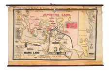
Stock# 85057
Description
Finely colored map of the region of the area of the Holy Land inhabited by the Tribe of Zebulon. This map was published in A Pisgah-Sight of Palestine. . . by Thomas Fuller in 1650.
The area is also referenced as Galilaea Inferior, with a number of Levi towns shown, as well as Nazereth, Bethlehem and Tiberius.
The map shows towns, mountains, rivers, encampments, important routes, and more. Biblical features can be found throughout, such as armies crossing the river and the armies of various troops encountering each other. Cities are shown. A coat of arms and a dedication appears in the upper left.
Reference
Laor, E. 281.
![Carte De La Syrie [Shows Cyprus and the Holy Land!]](https://storage.googleapis.com/raremaps/img/small/61321.jpg)