


|
||

|

|
|

|
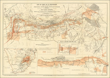
By the Cartographers Hired to Make the Official Field Intelligence Department Mapping for the Boe War. Local Imprint.
Important map of South Africa, published for a general audience, and showing the Boer region as it stood at the end of the first year of the Second Boer War (1899-1902). The map is interesting for differentiating between Boer and British lands using different colors, hence the title. The map was published by Wood & Ortlepp in South Africa.
The detail is very impressive on the map, with a special focus on topography. Six insets appear, with five city plans (Kimberley, Pretoria, Johannesburg, Ladysmith, and Dundee) and a regional map of southern Africa.
Wood & Ortlepp were perhaps the most important cartographers of South Africa from the Second Boer War period. They had been selected to produce a 31-sheet Imperial Map of South Africa, which was to be the most up-to-date mapping of the region, used only by the British Field Intelligence Department. While they were not allowed to disseminate that map until after the conflict, they did make use of their official status by issuing the current public map, as well as similar maps of contiguous regions, drawn to the same scale.
![Juta's Map of South Africa From The Cape To The Zambesi Compiled from the best available Colonial and Imperial Information Including The Official Cape Colony Map By The Surveyor General, Cape Town, Dr. T.Hahn's Damaraland, And E.C.Selous' Journals & Sketches &c. New and Revised Edition .. . . 1889 [2 Sheets in slipcase]](https://storage.googleapis.com/raremaps/img/small/85389.jpg)
![[Southwestern Coast of Africa] Pas-Caart van Guinea en de Custen daer aen gelegen Van Cabo verde tot Cabo de Bona Esperanca](https://storage.googleapis.com/raremaps/img/small/46931.jpg)
![[South Africa / Namibia / Angola] Coste Occidentale D'Afrique Depuis le XIe. Degre De Latitude Meridional, Jusqua'au Cap de Bonne Esperance Tiree de la Carte de l'Ocean Meridional . . . 1739](https://storage.googleapis.com/raremaps/img/small/77033.jpg)