|
||

|

|
|

|
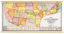
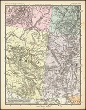
Fantastic large-format map of the state of Utah during the first decade of the 20th century, showing an incredible amount of information, down to the level of telephone lines by provider.
The map focuses on the natural resources of Utah. Gold, silver, copper, lead, iron, coal, hydrocarbon, and manganese deposits are all mapped. National forests and agricultural lands are shown as well. Roads, cities, townships, topography, and many additional features of importance are also shown. County boundaries are delimited in red. Below the map is an extensive listing of all the cities and towns in the state.
The Clason Map Company produced several large-format maps of western states and cities during the early 20th century, most of which are quite rare today.
Rarity
This is the only example of the map that we have been able to locate as appearing at auction. We trace only a single other example of the map, at the Huntington Library.