


|
||

|

|
|

|
A Remarkable Compendium of the Middle Ages with 3 Important Medieval Maps
Fine example of the work of French scholar and diplomat Jacques Bongars, illustrated with a number of important maps drawn from the work of perhaps the greatest early 14th Century medieval mapmaker Pietto Vesconte, representing the first ever facsmile works of Vesconte to appear in print and drawn directly from original manuscript examples of Vesconte's work.
In 1611, Bongars completed this magnificent compilation of transcriptions a number of manuscript chronicles of the crusades under the title Gesta Dei per Francos Sive Orientalium Expeditionum et Regnifrancorum Hierosolimitani Historia. Published in Hanover, Bongars' work was the first of a long tradition of publications devoted to publication of contemporary manuscript accounts of the Crusades and the history of the Roman Kingdom of Jerusalem.
Jacques Bongars Gesta Dei per Francos (“God’s Work Through the Franks”), is a remarkable collection of contemporary accounts of the Crusades. The work has been described as a milestone in crusade historiography, used until the early nineteenth century by most serious crusade historians.
The thirteen texts and fragments in Part 1 include most of the then surviving major narratives of the First Crusade. Part 2 is drawn from a Pierre Dubois's unique manuscript (which survives in a single example at the Vatican Library) and two manuscripts now in the Vatican, one likely derived from Petau consisting of a compendium of crusader advice and finally an important work prepared to advocate to Pope Clement V and later to Pope John XXII the religious and trade advantages of a new Crusade (described below) by Venetian Marino Sanudo Torsello, which is illustrated by maps and a Portolan chart of the Levant prepared for Sanudo by Pietro Vesconte.
Bongars work was produced as part of the greater intellectual movement that flourished in Europe, and in Germany in particular, roughly from 1450 to 1650, during which scholars, heavily influenced by the enlightened ethic of Humanism, sought to acquire, preserve and learn from the most progressive elements of Classical and Medieval thought. These scholars sought to go "ad fontes", or 'to the original source' of the knowledge, or as close to it as possible. Their legacy is the preservation of the great works which pre-date the modern printing era.
Marino Sanudo / Map of the World / Portolan of the Levant / Modern Map of the Holy Land / Plans of Jerusalem, Acre etc.
Marino Sanudo (Sanudo the Elder of Torcello, c. 1260-1338) was a Venetian stateman and geographer. He is best known for his lifelong attempts to revive the crusading spirit and movement. He wrote his great work, the Secreta or Liber Secretorum Fidelium Crucis, also called Historia Hierosolymitana, Liber de expeditione Terrae Sanctae, and Opus Terrae Sanctae, the last being perhaps the proper title of the whole treatise as completed in three parts or "books".
Sanudo's work discussed medieval trade and trade-routes as well as political and other history. In the work, he includes maps and plans which are of great importance in the development of cartography. Begun in March 1306, and finished (in its earliest form) in January 1307, the book was offered to Pope Clement V as a manual for true Crusaders who desired the reconquest of the Holy Land. To this original Liber Secretorum Sanudo added significantly. Two other "books" were composed between December 1312 and September 1321, when the entire work was presented by the author to Pope John XXII, together with a map of the world, a map of Palestine, a Portolan chart of the Mediterranean, Black Sea and west European coasts, and plans of Jerusalem, Antioch and Acre. A copy was also offered to the King of France, to whom Sanudo desired to enlist the military and political leadership for the new crusade.
The maps and plans which illustrate Sanudo's works are probably the work of the great portolan chart draughtsman Pietro Vesconte. Sanudo was certainly directly acquainted with Vesconte, and it is likely that his maps were faithful to Vesconte's originals. Although Vesconte's original world map does not survive, Sanudo's version of the the world map corresponds almost perfectly with other maps by Vesconte.
Twenty-three surviving examples of Sanudo's manuscript work are known to exist, all of which date from the 14th Century.
-- World Map
Johann Bongars' world map is the earliest surviving printed evidence of Pietro Vesconte's World map (circa 1311), generally considered to be one of the earliest surviving examples of a modern map of the world drawn in Medieval times. Vesconte's map, in its earliest form, survives in a 14th Century manuscript work by Marino Sanudo, which was reproduced for the first time in print in Bongars' Orientalium expeditionum historia. Gesta Dei per Francos, sive Orientalium expeditionum, et regni Francorum Hierosolimitani historia (Hanau, 1611). While not as broadly disseminated as the maps of Claudius Ptolemy, the Vesconte/Sanudo map is perhaps the single most important surviving cartographic artifact of the early 14th Century, providing great insight into the modern conception of the world, over150 years prior to the first printed maps.
As noted by Shirley:
[Printed for the first time] by Johann Bongars in 1611, Sanudo's planisphere . . . is one of the few examples of medieval maps based on portolano sources in printed form. It is a circular map centered on Jerusalem with the Mediterranean relatively well defined. The ocean surrounds the whole of the known world, the outer parts of which are represented by conjecture. The authorship of Marino Sanudo is not definitively established and the original manuscript map has also been attributed to Pietro Vesconte.
This mappa mundi (circular world map) is, in essence, a portolano of the Mediterranean world combined with work of pre-portolan type in remoter regions. The shore-lines of the countries well known to Italian mariners, from Flanders to Azov, are very progressively delineated, although Africa, away from the Mediterranean, is conventional, with its south-east projected, after the manner of Idrisi, so as to face Indian Asia, and with a western Nile traversing the continent to the Atlantic and the Niger shown in its classical fashion, extending due west to the Atlantic. Chinese and Indian Asia show little trace of the new knowledge which had been imparted by European pioneers from the time of Marco Polo, and which appears so strikingly in the 'Catalan Atlas of 1375'.
Its basic form also conforms to fundamental Medieval conceptions of geography, in that it is oriented with east at the top and shows Jerusalem at the center of the world. The ocean surrounds the known landmasses of the world, while the outer parts are largely conjectural. True to the Medieval conception of the world, the landmasses are about equally balanced between the Northern and Southern Hemispheres.
This all being said, however, in key respects the map was revolutionary for its time. Notably, this map, along with Vesconte's other work, features the first broadly accurate conceptions of the Mediterranean and Black Seas. Elsewhere In Europe, the appearance of Norvegia and Suecia (Scandinavia) are great advances from traditional cartographic sources attributable to Ptolemy, and Great Britain and the Baltic Sea appear in recognizable forms. The Arabian Peninsula, Black Sea and Caspian Sea are in a recognizable form, and the name Georgia appears above the Caucus Mountains. Some idea is also shown of the great continental rivers of the north, such as the Don, Volga, Vistula, Oxus and Syr Darya.
The present printed version of the map appeared in Germany in the early 17th Century. As noted above, it was part of a scholarly movement which sought to preserve "the original source'. As is the case with the antecedent of the present map, most of these sources existed only in manuscript form, available in a single or with very few examples. The portolan tradition was perhaps the most technically advanced element of of Medieval geography, and early modern scholars held it in high esteem. It was thus of great importance that the Sanudo/Vesconte World map was here for the first time printed, so that it could be disseminated to a wider audience. While the present printed edition of the map is uncommon, it is nevertheless responsible for creating and maintaining the scholarly awareness of this important map throughout Europe and beyond.
As noted in the History of Cartography, Volume 1, the Sanudo/Vesconte map was one of the most important maps of former times reclaimed for an Early Modern audience:
During the European Renaissance . . . it is possible to trace an increasingly systematic attention to the maps of preceding centuries. The extent to which this represented a genuine historical feeling for maps as independent documents should not be exaggerated, especially in view of the general surge of interest in the fifteenth and sixteenth centuries in classical geographical authors and the fact that maps from the classical sources were valued as useful contemporary tools as well as vaunted as monuments of antiquity. . . . historical maps were also reproduced, continuing a medieval tradition of manuscript copying in the Renaissance, but it was printed facsimiles of such maps that did the most to stimulate their study and widen an appreciation of the cartography of earlier centuries. Notable examples, engraved from medieval manuscript sources, were the Peutinger map . . . Marino Sanudo's medieval tract Liber secretorum fidelium crucial . . . and . . . Richard' Gough's maps of medieval Britain, [along with Ptolemy's maps].
Pietro Vesconte (fl. 1310-1330) was a Genoese cartographer and one of the earliest creators of portolan charts. He operated primarily out of Venice, and greatly influenced Italian and Catalan mapmaking throughout the 14th and 15th Centuries. He is widely regarded as having been the first professional mapmaker to habitually sign and date his works. Vesconte's portolan of the Eastern Mediterranean (1311), is the oldest known signed and dated map.
Vesconte created a groundbreaking 'Portulano', or World Map, which contained many geographically progressive elements. He was also the first mapmaker to accurately map the Mediterranean and Black Seas, and (relatively) the Holy Land and his depiction of Great Britain was a marked improvement over his predecessors. At least four of his multi-chart atlases survive, dating from 1313 to 1321.
A link to an example of a manuscript original can be found here: upload.wikimedia.org/wikipedia/commons/2/26/Sanudo_1321_World.jpg
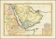
-- Map of the Levant
This interesting map of the Levant represents the earliest printed record of a manuscript drawn by Pietro Vesconte, which was presented to Pope John XXII by Marino Sanudo Torsello in 1321, as part of a grand proposal for a new crusade.
Oriented with East at the top, this remarkable medieval map of the Levant extends from Turkey to Mecca and Cairo, and includes a fine early depiction of Medieval Cyprus. The original manuscript map was drawn by Pietro Vesconte sometime between 1318 and 1321. Vesconte was the premier Portolan chartmaker in Venice between about 1310 and 1330, and was the author of the earliest known surviving Portolan chart of the Mediterranean which is signed and dated.
The present map is the earliest surviving printed example of the map of the Levant drawn by Pietro Vesconte for Marino Sanudo Torsello's Liber secretorum fidelium crucis (Book of Secrets of the Faithful of the Cross), prepared in 1321.
Pietro Vesconte was a Genoese cartographer and geographer, who was one of the most important and influential makers of Portolan charts. His map of the Levant combines the style of the medieval portolan maps in its treatment of the eastern Mediterranean, with a stylized medieval depicition of the lands between the coast, Mecca and the Tigris and Euphrates rivers. As noted in the abstract to the work of Stefan Schroeder:
The design of [Vesconte's] . . . differs considerably from other contemporary maps, such as the mappae mundi of Ebstorf and Hereford or the so-called ‘situs maps’ that present an idealised depiction of the city of Jerusalem. In total, the maps seem to focus on the transmission of geographic rather than religious knowledge, thus conveying the impression of a more ‘accurate’ view of the physical reality. As a consequence, they have been interpreted as marking the beginning of a new phase in the history of cartography that led towards modern practices of map-making. [However, Schoeder concluded that] . . .Vesconte’s maps do not represent a fundamental change concerning religious aspects in the perception of the world, [but instead are the result of a focus on geography] . . . from the use of Arabic- Islamic templates as well as techniques that characterise Portolan charts. Taken together, both features allowed the reader of Sanudo’s text to better visualise the author’s complex [crusadee] plan. Nevertheless, they did not diminish the maps’ potential to make it possible to contemplate God’s creation and to follow salvation history, an essential function of pre-modern maps. . . some elements of the maps even introduced new details of religious knowledge.
--Holy Land Map
Bongars's map of Palestine or the Holy Land is the first true, or unedited printing of the Vesconte map of the Holy Land (circa 1320), one of the most important and influential maps of the region ever produced. It depicts the Holy Land with an orientation with the east facing upwards (taken from the Medieval European Christian tradition of praying while facing eastwards, towards Jerusalem).
Bongars map retains the grid shown on Vesconte's antecedent manuscript map, which was employed to draft the map. While by no means precise, the map maintains a basic planimetric accuracy which allows it to be understood by the modern viewer, and is a considerable improvement over the Ptolemaic perspective. The coast of the Holy Land is shown to run roughly flat along the Mediterranean Sea, and features several familiar names, including Gaza, 'Ascalona' (Ashkelon), 'Cesarea' (Ceasarea), 'Acon' (Acre or Akko), 'Tyr' (Tyre, Lebanon) and 'Sydon' (Sidon, Lebanon). Inland is 'Ierlm' (Jerusalem, denoted by the sign of a castle), 'Beetlem' (Bethlehem), 'Ebron' (Hebron), 'Nazaret' (Nazareth) and Damascus, amongst others. The land is divided into the territories of the 12 Ancient Tribes of Israel and the landscape is adorned with many lengthy inscriptions discussing important locations and events from the bible, including an entertaining passage where Lot's wife was turned into a pillar of salt. It also shows the Sea of Galilee, with the River Jordan running into the Dead Sea, although it incorrectly shows a water connection between the Sea of Galilee and the Mediterranean.
Pietro Vesconte's map of the Holy Land, in its earliest form, survives in a circa 1320 manuscript work by Marino Sanudo, which is reproduced, unedited for the first time in print, in Bongars' Gesta Dei per Francos (Hanover, 1611). The Vesconte map is the single most influential map of the Holy Land of the Late Medieval and Early Modern eras. The Vesconte-Sanudo map formed the basis for all of the early "tabulae moderna" ('new maps', meaning Post-Ptolemaic) of the Holy Land made during the first decades of printing. Around 1480, the cartographer Nicolaus Germanus created a map of the Holy Land which was based on the Vesconte map, but which contained notable revisions. Germanus's map was published in both Francesco Berlinghieri's edition of Ptolemy's Geographia (Rome, 1482) and Lienhart Holle's edition of Ptolemy (Ulm, 1482). Germanus's work was reissued on many subsequent occasions, including by Martin Waldseemüller in 1513. Importantly however, Bongars's edition was the first true, or unedited, publication of the Vesconte Holy Land map.
While Nicolaus Germanus had issued an altered version of the Vesconte-Sanudo map, Bongars felt that it was important that the map be duplicated as it was originally conceived, and which had hitherto remained available in only a handful of manuscript examples, to be printed and disseminated to a wider audience.
Jacques Bongars, Seigneur de Bauldry et de La Chesnaye, was a French diplomat and classical scholar who compiled a history of the Crusades.
A Huguenot, Bongars studied in Germany, Italy, and Constantinople. From 1586 Henry of Navarre (later King Henry IV of France) sent him on missions to obtain men and money from the German princes and from Queen Elizabeth I of England. As French minister in Germany (1593–1610) he tried to unite Protestant princes in a league with King James I of England at its head.
Bongars published an annotated edition of the Roman historian Justin’s works in 1581 and a French translation of the letters of Aristaenetus in 1597. He was interested, however, not only in ancient writings but also in medieval chronicles. His collection of historical works on Hungary (1600) was followed, in 1611, by the far more important Gesta Dei per Francos (“God’s Work Through the Franks”), a collection of contemporary accounts of the Crusades. An edition of his letters, in Latin, appeared in 1647, a French translation in 1668–70. His diary of his journey to Constantinople was printed in 1874.
Pietro Vesconte was a fourteenth-century mapmaker best known for his pioneering portolan charts. Born in Genoa, he performed the bulk of his work in Venice between 1310 and 1330.
While portolan charts are known to have existed since at least the thirteenth century, Vesconte significantly improved on the form and produced highly-accurate charts of the Mediterranean, the Black Sea, and Northern Europe. His 1311 chart of the eastern Mediterranean is the oldest signed and dated nautical chart. He also made at least four signed atlases. One of these, a 1318 atlas, includes an image of a chartmaker at work which is likely Vesconte. The cartographer also made several maps, including a distinctive mappa mundi included in Marino Sanuto’s Liber secretorum fidelium crucis.
![[ World ] Nova Totius Terrarum Orbis Geographica Ac Hydrographica Tabula Auct. Henr: Hondio. . . . 1641](https://storage.googleapis.com/raremaps/img/small/85386.jpg)
![[Arabian Peninsula] Sexta Asie Tabula [Arabia Felix.]](https://storage.googleapis.com/raremaps/img/small/84313.jpg)

![[ Janet Taylor -- Pioneer English Astronomer and Naval Navigation Expert ] Chart to Accompany R. Russel's Diagram of Great Circles / R. Russel's Diagram of Great Circles](https://storage.googleapis.com/raremaps/img/small/98801.jpg)