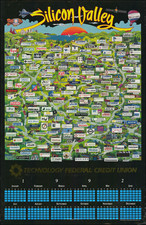


|
||

|

|
|

|
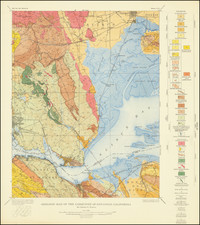
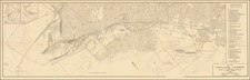
Original antique geological map of the uppermost Bay Area, centered on Benicia. Showing an area of some 100 square miles in size in great detail, this map includes an extremely detailed early look at the geology of the region. The map shows topography, settlements, and more. The map was produced by the USGS based on information compiled by Charles E. Weaver.
Cities shown on the map include Benicia, Carquinez, Eckley, Valona, Crocket, Vallejo Junction, and Vallejo. Geographically, this is one of the most detailed vintage maps to focus on the region.
The geology of this region includes many younger rocks, although older intrusive rocks do pop out in some areas. Dips, strikes, and other geological measurements are shown throughoiut. Boundaries are indicated.
![[ Washington Township / Murray Township ] Res. & Stock of J.T. Walker, Washington on Corners & Residence and Farm of Christian Knittel, Murray Tp, Alameda County, California](https://storage.googleapis.com/raremaps/img/small/102042.jpg)