|
||

|

|
|

|
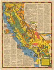
Rare 1834 Finley Mexico with Important Early Texas Improvements
Rare 1834 edition of Finley's map of Texas, Upper California, New Mexico and Mexico proper, from Finley's General Atlas.
This is the final edition of the map, providing a comprehensive update in Texas on the eve of its Independence.
The 1830 edition of the map showed Austin's Settlement and San Felipe de Austin in Texas and was the first edition to show "Coahuilla and Texas" as a Mexican Province, having previously been part of San Luis Potosi. This 1834 edition removes the note about Austin's settlement but is vastly updated with new settlements and improved treatments of Texas hydrography.
San Felipe de Austin has been moved significantly down river and the Coast of Texas is dramatically revised. Nacogdoches is moved and the river system around it completely updated.
New place names included:
- Ft. de Altar
- Harrisburg
- Brazoria
- Matagorda
- Victoria
- Galiod (Goliad)
- Gonzaley
The map focuses on showing Texas and Upper California (New Albion and New California), showing the Spanish Intendencies of San Luis Potosi, New Mexico, Durango and Sonora, among others.
Includes the mythical lakes of Timpanogos and Teguayo on the River Buenaventura, which reached from San Francisco Bay to Salt Lake.
Rarity
This is the first time we have ever seen the 1834 map offered for sale.
Anthony Finley (1784-1836) was an American map publisher. Little is known about his life. He is presumed to have been born in Philadelphia, where he also died. A publisher, Finley was also involved in several Philadelphia civic and professional societies such as the Philadelphia Apprentices’ Library. He may have been in business as early as 1809 and his first publication dates from ca. 1811.
His first maps also date from this year, with two maps in Daniel Edward Clarke’s Travels in Various Countries of Europe, Asia, and Africa. The first atlas published by Finley appeared in 1818, the Atlas classica, or, Select maps of ancient geography, both sacred and profane, for the use of colleges and schools in the United States. He is best known for his A New General Atlas Comprising a Complete Set of Maps (1824), which was a bestseller. There were two editions in 1824, with annual editions until 1834.
Finley was part of the first generation of American publishers who produced high quality, precise maps on American soil. He was in competition with other Philadelphia publishers, for example Henry S. Tanner. Finley’s A New American Atlas Designed Principally to Illustrate the Geography of the United States of America (1826) closely mirrors Tanner’s A New American Atlas Containing Maps of the Several States of the North American Union, with similar groupings of maps; the main difference is the smaller scale of Finley’s maps. Finley printed two editions of this atlas.

![[Dallas / Kennedy Assassination] La Mappa Dell'Odio](https://storage.googleapis.com/raremaps/img/small/89006.jpg)