
This item has been sold, but you can enter your email address to be notified if another example becomes available.


|
||

|

|
|

|
Stock# 84914
Description
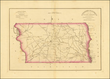
Warner and Beers's scarce atlas map of the southeast, showing North and South Carolina, Georgia, Florida, and parts of adjoining states. Detail is shown down to the county level.
Railroads, cities, towns, and more are shown. Includes a decorative border.
Condition Description
Original hand-color. Very scant soiling and minor tear in lower margin.
![[ Florida / Georgia Coastline ] A Plan of Amelia Harbour and Bar, in East Florida, Surveyed by Jacob Blamey, Master of His Majesty's Schooner St. John](https://storage.googleapis.com/raremaps/img/small/38028.jpg)


![[St. Augustine, Florida] Beschreibung des Vorgebürgs Floride/ da die Franzosen anzufahren pflegen/welches von ihnen das Französische Vorgebürg genannt wirdt.](https://storage.googleapis.com/raremaps/img/small/84381.jpg)