|
||

|

|
|

|
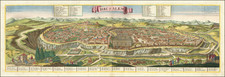
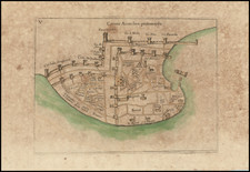
Fine example of Seutter's strong impression that highlights Seutter’s combination plan and prospect of Jerusalem.
The top image is a plan of the ancient city after Villalpando's plan. The bottom image provides a striking birdseye view, which follows the image of Matthaus Merian.
The upper image includes a key location 47 points of interest, with 8 points noted in the lower view.
Born in Augsburg and a son of a goldsmith, Seutter was an apprentice to Johann Baptist Homann, a renowned atlas maker, whom he eventually replaced as the official geographer to the Kaiser of the Holy Roman Empire.
Matthäus Seutter (1678-1757) was a prominent German mapmaker in the mid-eighteenth century. Initially apprenticed to a brewer, he trained as an engraver under Johann Baptist Homann in Nuremburg before setting up shop in his native Augsburg. In 1727 he was granted the title Imperial Geographer. His most famous work is Atlas Novus Sive Tabulae Geographicae, published in two volumes ca. 1730, although the majority of his maps are based on earlier work by other cartographers like the Homanns, Delisles, and de Fer.
Alternative spellings: Matthias Seutter, Mathaus Seutter, Matthaeus Seutter, Mattheus Seutter
![(Jerusalem - Temple of Salomon) Templum Salomonis [with Perugia on verso]](https://storage.googleapis.com/raremaps/img/small/96662.jpg)
![[Jerusalem] Antiquae Ierusalem vera Icnographia Ad Sacrae Lectionis Praecipue et Aliarum de Illa Urbe Historiar. Expiicationem Ex collatione actoru cu ruinaru uestigijsac Situ ipso.](https://storage.googleapis.com/raremaps/img/small/83738.jpg)