|
||

|

|
|

|
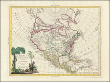
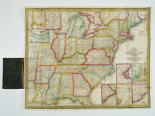
Landmark First Map of North America To Appear In A Commercial Atlas
In the annals of historical cartography, Cornelis De Jode's map of North America stands as an emblematic representation of the fluidity and uncertainty with which European powers approached the "New World" in the late 16th century. De Jode's map holds the distinction of being the first full-folio-size atlas map focused primarily on North America, a pioneering endeavor only preceded by the rare separately issued Forlani/Zaltieri map in 1565 and miniature map in Porcacchi's L'isole piu famose del mondo of 1572.
De Jode's primary source of inspiration was the eighteen-sheet world map crafted by Petrus Plancius in 1592. His map is also renowned for incorporating data from the two maps published by Theodore de Bry in 1590 and 1591, based on works by John White and Jacques le Moyne, respectively, and stands as a remarkable, if somewhat contradictory, compendium of modern exploration up to the beginning of the 1590s. Theodore de Bry, a prominent engraver and publisher, was renowned for his compilations of voyages, complete with intricate illustrations and maps. His 1590 publication drew from John White's sketches, providing a detailed perspective of the Virginia region. A subsequent 1591 publication was based on Jacques le Moyne's representations of Florida. White, an English artist and cartographer, participated in Sir Walter Raleigh's expeditions to the New World. His meticulous drawings and maps of the Virginia and Carolina regions gave one of the first English insights into Native American cultures and landscapes. On the other hand, le Moyne, a French artist, focused his work on the Florida area. His illustrations and maps became a primary source for Europeans on the region's geography and indigenous people.
The map provides a glimpse into the limited and often contradictory knowledge Europeans had about North America's geography, even a century after its discovery. Regions between Virginia and the Gulf of St. Lawrence remained especially enigmatic. The blend of English reports from the Carolinas and French accounts from maritime Canada created a distorted, and often inconsistent, depiction of the Eastern seaboard. De Jode's map showcased several inaccuracies. A significant error was the misplacement of the middle Atlantic coast, especially the Chesipooc Sinus (Chesapeake Bay). De Jode placed it 4° to 6° too far north, essentially positioning it alongside present-day southern Maine.
Another notable error was the positioning of Cape Arenas, likely representing Cape Hatteras. Historically depicted on maps since Giacomo Gastaldi's "Tierra Nueva" from 1548, it had traditionally been placed at latitudes of around 38° to 40°. De Jode, however, situated it even further north, contrasting its actual latitude closer to 35°. In comparison, the English historian Richard Hakluyt's 1587 map depicted Virginia more accurately, placing it correctly above Cape Arenas. Yet, when De Bry released John White's Virginia map in 1590, which notably lacked latitudinal markings, De Jode incorporated it above his mispositioned Cape Arenas. This choice further distorted the geographical representation, pushing the entire coastline further north than its real location.
Noteworthy features of the map include its audacious portrayal of a double Northwest passage and the depiction of the St. Lawrence River stretching ambitiously to Texas. Myths and legends, like the fabled city of Cebola paved in gold and an inland lake associated with Marcus Niza, weave into the map's topography, highlighting the blend of empirical observations with the lore and legends of the time.
Jacques Cartier and the St. Lawrence River: The map vividly presents Jacques Cartier's exploration and the subsequent discovery of the St. Lawrence River, an essential waterway that opened Canada to European explorers. Over his three voyages (1534, 1535, 1541–42), Cartier sailed from the Atlantic Ocean and explored the Gulf of St. Lawrence and ultimately far up the St. Lawrence River, establishing a French claim on modern-day Quebec and laying the foundation for New France. De Jode's map captures Cartier's voyages, showcasing the initial inroads into the North American interior with an exaggerated depiction of the St. Lawrence far into the interior of the continent.
Lake Conibas and the Quest for the Northwest Passage: Prominently depicted on the map is Lake Conibas, a mythical great lake. This lake is emblematic of the period's unending search for the Northwest Passage—a direct sea route to Asia. Lake Conibas became the embodiment of hopes that such a passage existed, leading directly through North America. Throughout the 16th century, the Northwest Passage remained a significant objective for many explorers, including Martin Frobisher, John Davis, and Henry Hudson. Each sought the elusive waterway, and while none succeeded, their efforts provided invaluable geographical knowledge.
Mythical Islands and the Atlantic: The map is dotted with several mythical islands, representing a mix of early misinterpretations and long-standing legends. Notably:
-
Frisland: Often confused with parts of Iceland or Greenland, Frisland was a regularly charted island that never existed.
-
St. Brendan's Island: Stemming from the tale of Irish monk St. Brendan, this island was said to exist somewhere in the Atlantic and appeared on maps until the 18th century.
-
Drogeo dis Cirnes Gallis: Another imaginary land, the origins of which remain ambiguous, but its continued inclusion on maps showcases the persistence of cartographic myths.
Atlantic Annotations and Early Exploration: Several notes are scattered across the map's Atlantic portion, providing a glimpse into the early exploration:
-
"Terra Corterealis, ab ipso Ao. 1500 a Capite de Mavas usque ad Rio Nevado detecta": This references the explorations of Gaspar Corte-Real, a Portuguese explorer. In the early 16th century, he explored parts of modern-day Canada, including Newfoundland.
-
"Baccalaos; Ao. 1507 a Sebastiano Gabat: [Cabot]": This note refers to Sebastian Cabot, son of the famed explorer John Cabot. Specifically, it alludes to Sebastian's 1508–09 expedition in search of a North-West passage through North America. During this journey, Sebastian reached high latitudes, encountered vast fields of icebergs, and identified a potential open waterway. However, due to the challenging conditions, he was compelled to turn back without navigating the entire passage.
-
"C. de Breto, Iohanne Verazono Florentino Ao. 1529 nomine Regis Galliae, detectu": Giovanni da Verrazzano, an Italian explorer, is referenced here. Sailing under the French flag in the 1520s, he explored the American East Coast. The note's morbid ending recounts a widely-believed tale that Verrazzano was captured and eaten by Carib natives.
At the far left, a note describes the people in the region between "Baccalaos and Florida" as follows:
"Qui inter Floridam et terram Baccalaos habitant, hi omnes uno nomine Canadenses appellantur: sed diversae nationes populorum, sunt Hochelaga, Hongueda, Corterealis, praeceteris benigni et humani."
Translation: "Those who dwell between Florida and the land of Baccalaos are all called by one name, Canadians. However, they are diverse nations of people; among them are Hochelaga, Hongueda, and Corterealis, notably benign and humane compared to the others."
This passage offers insight into the naming conventions and European perspectives of indigenous groups residing in the northeastern parts of North America. Floridam refers to Florida and Baccalaos, what Europeans named the regions around Newfoundland, respectively. The term "Baccalaos" was associated with the cod fisheries and was an early name for parts of northeastern North America. Canadenses: The term seems to be an early derivation of "Canadians." It’s interesting to see that even in those early days of exploration, there was some sort of broad designation for the peoples of this vast region, despite the wide variety of cultures and tribes. Hochelaga is an early name for the area around present-day Montreal. It was also the name of a significant Iroquoian village encountered by Jacques Cartier during his second voyage in 1535.
The treatment of the American Southwest is also noteworthy. In the late 16th century, the Spanish were driven by intense exploration ambitions in the New World. Among their quests was the search for the fabled cities of gold in the American Southwest, often dubbed the Seven Cities of Cíbola. This legend, rooted in Iberian tales, spoke of seven bishops who, fleeing Muslim conquerors, founded cities of untold riches in a distant land. By the time the Spanish arrived in the Americas, the legend transformed into tales of golden cities lying north of New Spain (modern-day Mexico).
Francisco Vázquez de Coronado, an ambitious conquistador, embarked on the most renowned expedition in pursuit of Cíbola between 1540 and 1542. Instead of vast wealth, he discovered the Zuni Pueblo in today's New Mexico, debunking the tales of opulent cities. "Septem Citta" on maps perpetuated the Seven Cities legend, and "Tonteac" might relate to other indigenous settlements in the region, though its exact identification remains unclear. The note on De Jod's map, "Marcus Nizza asseverate Provincia Septe Citta Valde esse nobilem," relates to the testimony of the Franciscan friar Marcos de Niza. He claimed the province of the "Septem Citta" (Seven Cities) was exceptionally noble, further fueling the allure of the legend.
The map also discusses the French exploration of Florida in the 1560s, with the note:
Galli sub Capitaneo Ribaldo, primo in Floridam peruenerunt, A.1561. vbi edificarut Charlesfort arce, ab ipsoru Rege Carolo 9.sic appellatam Se cunda navigatio suit sub Capit. Laudouniere, A 1563.et aedisicaverut Carolina. Qua A 1565. 21 Septemb. ab Hispanis capta fuit. Gallis omnes cu ipsoru Capit. Ribaldo preter data fide taquam haretici interfecti"
The French under Captain Ribault first arrived in Florida in A.D. 1561. There they built a fort called Charlesfort, named after their King Charles IX. A second expedition was under Captain Laudonnière in A.D. 1563, and they built Carolina. On September 21, 1565, it was captured by the Spanish. All the French, including their Captain Ribault, were killed by the Spanish against the given trust as heretics."
The quote refers to the early French expeditions to the southeast and particularly Florida. These expeditions were part of France's attempt to establish a foothold in the New World and expand its colonial territories. Under the leadership of Jean Ribault in 1561, the French established Charlesfort, but this settlement was short-lived due to challenges like supply shortages and tension with indigenous communities. In 1563, René Goulaine de Laudonnière led another expedition and founded Fort Caroline, sometimes referred to as "Carolina" in the context of this quote. This became the center of the French colony of La Florida. However, the French presence was not tolerated by the Spanish, who considered Florida to be part of their territory due to prior exploration. On September 21, 1565, Spanish forces under Pedro Menéndez de Avilés attacked Fort Caroline, and despite a truce agreement, executed Ribault and many of his men on the grounds of heresy.
Another fascinating quote about Sir Walter Raleigh's founding of Virginia states:
"Eam Regionem, qua hodie Virginiam appellamus, A. 1585 sumptibus Walteri Ralegh Angli detexerunt. Regio, Aluminis, Vini, ferri, Eris, Cedri, omnium necessariorum feracissima frumenti incredibilis profectus. Gens mediocri statura, chlamyde è cervina pelle, tecta. Arma arcus sunt, et stipites lignei. Oppida exigua, mari vicina sunt, 10. aut 12 aedes, raro amplius, habet. Poenae etiam in delinquentes institutae sunt."
Translation: "That region, which we call Virginia today, was discovered in 1585 at the expense of the Englishman Walter Ralegh. The region is incredibly fertile in aluminum, wine, iron, millet, cedar, and all necessary things with an unbelievable growth of grain. The people are of average height, covered in deer-skin cloaks. Their weapons are bows and wooden shafts. The towns are small, close to the sea, having 10 or 12 houses, rarely more. Punishments have also been established for offenders."
The map even offers observations on indigenous cultures, including those far from areas actually explored. For example, between Lac Conibus and the Northwest Passage, a note reads "Incolæ baru Regionu, piscibus magna ex parte vivunt, et pellibus feraru vestiuntu" (The inhabitants of this region largely live on fish and are clothed in animal skins.).
In essence, Cornelis De Jode's map is more than a mere geographical representation—it's a documentation of an era marked by discovery, wonder, and the enduring spirit of exploration. Combining known geographical details with myths and legends, the map stands as a testament to humanity's quest for knowledge and the sometimes-blurred lines between fact and fiction in this pursuit.
De Jode's map was issued with the second edition of the atlas "Speculum Orbis Terrarum", first published by Gerard de Jode and later completed by his son, Cornelis.
![[Parts for a Klinger globe]](https://storage.googleapis.com/raremaps/img/small/46375.jpg)