


|
||

|

|
|

|
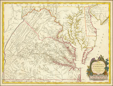
First State of the Earliest French Map to Incorporate the Seminal Mapping Work of Joshua Fry and Peter Jefferson.
Striking example of the single sheet version of the seminal Fry-Jefferson map of Virginia and Maryland, engraved by Elisabeth Haussard and published in Paris by Robert De Vaugondy for the Atlas Universel.
A well executed reduction of Joshua Fry and Peter Jefferson's landmark, which was originally issued separately and later appeared in Jefferys' American Atlas. The result is a beautiful single folio sheet example of the most sought after and recognizable 18th Century map of Virginia and Maryland. While the title is in French, virtually all of the place names and annotations are in English. The map provides a fabulously detailed look into pre-revolutionary war Virginia and Maryland, extending west to the Alleghany Mountains, and including Delaware and a portion of New Jersey, as well as the region around Philadelphia.
Originally prepared by Joshua Fry of William & Mary and Peter Jefferson (father of President Thomas Jefferson) at the request of Lord Halifax in 1748, the Fry-Jefferson was a monumental leap forward in the mapping of the region. It is the first map to accurately depict the Blue Ridge Mountains and the first to lay down the colonial road system of Virginia. A great number of plantations are located and include the family names of the Virginia plantation owners of the period. The cartouche, showing a tobacco warehouse and wharf, is one of the earliest printed images of the Virginia tobacco trade.
One of the first actions of Lord Halifax upon becoming president of the Board of Trade and Plantations in 1748, was to request information concerning activities in the Frontiers and of potential French encroachments on the British territorial claims. In 1750, the Board required that each colony conduct a comprehensive survey. The acting Governor of Virginia, Col. Lewis Burwell, commissioned Fry & Jefferson to prepare a map of the Virginia colony.
Joshua Fry, a mathematician at the College of William and Mary, and Peter Jefferson, a surveyor (father of Thomas Jefferson), had together previously drawn the boundaries of Lord Fairfax's lands in 1746, and surveyed the Virginia-North Carolina boundary in 1749. First issued in 1751, the Fry-Jefferson map incorporates the original surveys of Fry & Jefferson with existing data. A major revision in 1755 incorporated important information about the western part of the colony from the journals of John Dalrymple and Christopher Gist, the latter of whom is credited in the upper left part of the map with having contributed to the revisions. It is the 1755 edition that forms the basis for the subsequent editions.
States of the Map
The present De Vaugondy version of the map is known in 5 states:
- State 1: Dated 1755. Gravee E. Haussard. Lord Fairfax line shown. Pennsylvania-Maryland boundary delineated only up to the Monongahela River.
- State 2: Dated 1755. Gravee E. Haussard. Lord Fairfax line removed. Pennsylvania-Maryland boundary delineated to the far western terminus of the map. (1757 ca)
- State 3: Dated 1755. Groux (engraver). Lord Fairfax line removed. Pennsylvania-Maryland boundary delineated to the far western terminus of the map. (1778 ca)
- State 4: Dated 1755. Groux (engraver). Lord Fairfax line removed. "Geographe Ordinaire du Roi" is now shortened to "Geographe Ordinaire and the privilege is removed.
- State 5: Undated. Groux (engraver). "Ordinaire du Roi" no longer appears below De Vaugondy's name in the title. (1793 ca).
Gilles Robert de Vaugondy (1688-1766) and Didier Robert de Vaugondy (1723-1786) were influential figures in the realm of 18th-century French cartography. Originating from Paris, their contributions to mapmaking were significant during an era of expansive geographical exploration.
Gilles Robert de Vaugondy entered the world of cartography not through family tradition but through personal interest and the budding opportunities of his time. Born in 1688, he worked during a time when Paris was becoming a central hub for cartographic activities. Gilles often incorporated the latest findings from explorers into his maps, making them sought-after for their contemporary relevance. His connections weren't limited to his immediate circle; he frequently interacted with other key mapmakers, staying updated on the latest techniques and findings.
His son, Didier, was born in 1723 and had the advantage of growing up surrounded by maps and globes. While his father was renowned for maps, Didier made a name for himself in the field of globemaking. His globes were some of the most precise and detailed in France, gaining recognition even among the royalty. In addition to his work in cartography and globemaking, Didier had a keen interest in education, especially after the expulsion of the Jesuits from France. He stepped in to produce geographical educational materials, fulfilling a newfound need.
The maps and globes produced by the Vaugondys remain an enduring testament to the peak of French cartography during the Enlightenment. Their works, characterized by precision and the inclusion of contemporary findings, helped to shape our understanding of the world during a transformative period in European history.


![[British Colonies in America] Carte Qui Contient Une Description Des Iles & Terres Que Les Anglois . . .[maps of Chesapeake, Carolinas, New England, Bermuda, Gulf Coast, Jamaica, Barbadoes & Canada]](https://storage.googleapis.com/raremaps/img/small/61480.jpg)
![[ English Plantations in North America ] A New Map of the most Considerable Plantations of the English In America Dedicated to His Highness William Duke of Glocester.](https://storage.googleapis.com/raremaps/img/small/98233.jpg)