This item has been sold, but you can enter your email address to be notified if another example becomes available.


|
||

|

|
|

|
Stock# 84850
Description
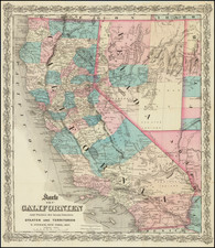
Nice map of California and Nevada with topographic detail, which appeared in the 1870s in atlases by Warner & Beers.
The map is colored by county. Shows towns, railroads, roads, rivers, mountains, dry lakes, Indian tribes, etc.
Pre-dates the creation of Orange, Imperial, and Riverside counties in Southern California as well as Modoc and San Benito in Northern California.
Condition Description
Original hand-color by county. Minor soiling in bottom margin.
![[ Ventura ] Automobile Road Map of Ventura County California . . .](https://storage.googleapis.com/raremaps/img/small/99431.jpg)
![(Bird's-Eye View of California) San Francisco Invites You [cover title]](https://storage.googleapis.com/raremaps/img/small/92552.jpg)