The item illustrated and described below is sold, but we
have another example in stock. To view the example which
is currently being offered for sale, click the
"View Details" button below.

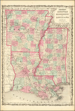
1797 Jedidiah Morse / Abraham Bradley
$ 975.00


|
||

|

|
|

|
Stock# 84828
Description
Early map of the Southern portion of the US, extending from the Atlantic to the Mississippi and showing part of Kentucky. Georgia Western Territory extends to Mississippi and is separately named from Georgia, with a dashed line, noting that both Georgia and the US claim this land. West and East Florida are still named. Tennessee is now a state, and Knoxville, Sullivan, Jonesboro, Greenville and Nashville all appear. Many Indian Tribes, Villages, forts and Court Houses are named. This was one of the earliest regional maps of the South published in the US and reflects the primitive state of the settlements west of the Appalachians. Backed on linen.
![[North Carolina]. Carte Geographique, Statistique Et Historique De La Caroline Du Nord](https://storage.googleapis.com/raremaps/img/small/57603.jpg)