


|
||

|

|
|

|
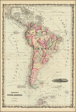
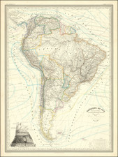
The Best English Map of South America of The Early 19th Century
Exceptional map of South America, at the outset of its Century of Independence, without question the finest large format commercially published map of South America published in the early 19th Century.
The map is based upon original manuscript maps to His Excellency the late Chevalier Pinto and João Joaquim da Rocha, João da Costa Ferreira, El Padre Francisco Manuel Sobrevida &c. and from the most authentic edited accounts of those countries. The geopolitical divisions would drastically be altered in the years to come as a consequence of the Independence and creation of Republics of most of South America from Spain's colonies. It is also, due to its scale, extremely detailed and includes as much up-to-date information as was by then available. The map is embellished with an enormous title cartouche on the lower right sheet.
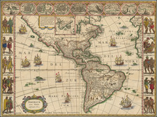
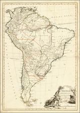
The 1775 Cruz Cano and Faden's 1807 Colombia Prima
Coming only 8 years after Faden's publication of the Cruz Cano y Olmedilla map of South America, it is remarkable to see the dramatic improvements. The Cruz Cano had originally been published by the Spanish Government in 1775, but had been suppressed shortly after it publication. Cruz Cano's map was based on cartographic material of Consejo de Indias, Jose de Ayala and the reports of the Jesuits and other missionaries in South America. Cruz Cano had spent ten years collecting measurements made by explorers and colonists and incorporated in the map valuable geographical and historical news, with some references to the sources used. Measuring approximately 6 x 8 feet, the Cruz Cano map is probably the most important map of South America made in the 18th century.
Link to 1799 Faden/Cruz Cano: /gallery/detail/51845
Faden had originally been tasked with publishing an English edition of the Cruz Cano by Thomas Jefferson. As noted by Smith:
In spite of the fact that it was an official project, initiated and paid for by the Spanish Government, it appears to have been withheld from public distribution for a quarter-century following the first printing in 1775. Consequently, it was seldom on the market. . . .
In correspondence where Jefferson sought to have Faden copy the map, Jefferson described the map and its importance:
The government of Spain at first permitted the map, but the moment they saw one come out, they destroyed the plates, seized all of the few copies which had got out and on which they could lay their hands, and issued the severest injunctions to call in the rest and to prevent their going abroad. Some few copies escaped their search. A friend has by good management procured me one, and it is arrived safe through all the searches that travelers are submitted to.
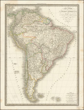
In comparing the two maps (1799 and 1807), it is quite remarkable to see the advancements from the 1799 Faden/Cruz Cano to the 1807 Faden/Colombia Prima. These changes can be seen both stylistically and in terms of the significant improvements in both the topographical information in depicted in the 1807 map and the tremendous advancements in the coastal features.
Notably, the southern coast of Chile is radically different and the 1807 goes so much further in illustrating the topography and highlighting the topographical features (i.e., mountains) which defines Chile's geography.
The Coastal advances are unquestionably the result of the Spanish Hydrographical surveys of the late 18th Century, which resulted in the first comprehensive scientific observations along the entire coast of South America. Taken as a whole, both the stylistic and geographical differences between the two maps is quite remarkable.
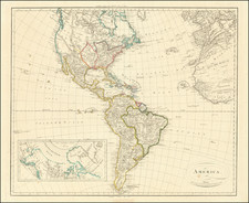
States of the Map
We note states of the map dated 1807 and 1820 (designated third state), and later states by James Wyld dated from 1823 to as late as 1872.
There is also a proof state, with Colombia spell Columbia.
Rarity
The Faden map is scarce on the market. We note only 1 example of the 1807 edition at auction in the past 20 years.
OCLC locates copies in the British Library, Clements Library (Michigan), Syracuse University, Harvard, State Library of New South Wales and the Rumsey Collection (Stanford). The JCB and National Maritime Museum hold a 4th edition, dated 1828. The Newberry Library holds a copy bound into a Wyld General Atlas. The British Library also lists an 1872 edition.
William Faden (1749-1836) was the most prominent London mapmaker and publisher of the late-eighteenth and early-nineteenth centuries. His father, William Mackfaden, was a printer who dropped the first part of his last name due to the Jacobite rising of 1745.
Apprenticed to an engraver in the Clothworkers' Company, he was made free of the Company in August of 1771. He entered into a partnership with the family of Thomas Jeffreys, a prolific and well-respected mapmaker who had recently died in 1771. This partnership lasted until 1776.
Also in 1776, Faden joined the Society of Civil Engineers, which later changed its name to the Smeatonian Society of Civil Engineers. The Smeatonians operated as an elite, yet practical, dining club and his membership led Faden to several engineering publications, including canal plans and plans of other new engineering projects.
Faden's star rose during the American Revolution, when he produced popular maps and atlases focused on the American colonies and the battles that raged within them. In 1783, just as the war ended, Faden inherited his father's estate, allowing him to fully control his business and expand it; in the same year he gained the title "Geographer in Ordinary to his Majesty."
Faden also commanded a large stock of British county maps, which made him attractive as a partner to the Ordnance Survey; he published the first Ordnance map in 1801, a map of Kent. The Admiralty also admired his work and acquired some of his plates which were re-issued as official naval charts.
Faden was renowned for his ingenuity as well as his business acumen. In 1796 he was awarded a gold medal by the Society of Arts. With his brother-in-law, the astronomer and painter John Russell, he created the first extant lunar globe.
After retiring in 1823 the lucrative business passed to James Wyld, a former apprentice. He died in Shepperton in 1826, leaving a large estate.