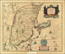
|
||

|

|
|

|
Interesting and scarce pictorial map of Taiwan, showing the independent island nation in attractive detail. The map shows roads and railroads and names many cities, but its most interesting feature are the many pictorial elements that can be found throughout.
The eastern end of the island is populated by large hills, while the historical and modern people of Taiwan are shown in various places. Modernization efforts appear in the north and west of the country. The map was evidently made for attracting tourists.
The map is dated October 25th, the 37th year of the Republic of China. This uses the Taiwanese dating system that established the start of the Gregorian calendar at the founding of the Republic of China, in 1911, which indicates the map was published in 1948. This follows the traditional Chinese practice of starting dating at the ascension of a new regime.
The map was edited by Xie Baishou and printed by Ping Ming Press.
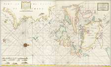
![[ Hong Kong, Canton & Environs ] Carte des Isles qui sont a L'Entree de la Riviere De Canton](https://storage.googleapis.com/raremaps/img/small/74493.jpg)
![The Map of China [Huang Ming yitong fang yu bei lan -- Comprehensive view map of the Imperial Ming]](https://storage.googleapis.com/raremaps/img/small/99110.jpg)