|
||

|

|
|

|
Stock# 84673
Description
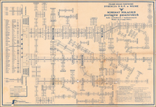
Mapping The Democratic Republic of Latvia
Finely drafted Latvian-language map of Latvia, crediting A. Oschin and P. Mantnieks of the Riga Institute of Cartography, with place names by Professor Endzelina.
Includes a key identifying various map details, as well as statistical information at the top right, including geographical information, railroads, public education, commerce, monetary units, and borders.
The map was published several years after Latvia gained its independence (1920-21) and adopted a constitution (1922), but prior to the coup d'etat of Prime Minister Kārlis Ulmanis in 1934.
Condition Description
Several fold splits and tears, expertly repaired on verso.
![Moscovia Parte Orientale . . . [with] Parte Occidentale . . .](https://storage.googleapis.com/raremaps/img/small/26615.jpg)
![Chart of the North and Baltic Seas [insets of St. Petersburg, Heligoland and Revel]](https://storage.googleapis.com/raremaps/img/small/72115.jpg)
![[ Holy Roman Empire, Poland, Baltic, etc. ] Germania VI Nova Tabula (First state!)](https://storage.googleapis.com/raremaps/img/small/94645.jpg)