This item has been sold, but you can enter your email address to be notified if another example becomes available.


|
||

|

|
|

|
Stock# 8466
Description
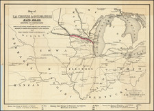
Decorative and detailed map of Illinois, hand colored by counties and showing the various railroads, stations, and other information. Decorative border. From HH Lloyd's scarce atlas of the United States, which was never separately published and only appears in regional atlases by Warner & Beers.
![[ Michigan & 3 Great Lakes ] Amer. Sep. No. 42 Haut Canada Et Michigan](https://storage.googleapis.com/raremaps/img/small/98409.jpg)