


|
||

|

|
|

|
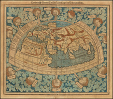
The Borgia Mappamundi
Fine late-eighteenth century printing of the famed fifteenth-century Borgia mappamundi, one of the few surviving medieval mappamundi.
Discovered by Cardinal Stefano Borgia in Portugal in 1774, this remarkable medieval world map is believed to have been made between about 1410 and 1450. It is now one of the treasures of the Vatican Library in Rome.
While much is known about its collector, Cardinal Borgia, almost nothing is known about the map’s maker. Nomenclature suggests it was made in southern Germany. The wealth of detail about the world’s peoples and its history suggest that it was intended for educational purposes and meant to hang on a wall.
Most likely created in the first half of the 15th Century, the original mappamundi consists of two engraved metal tablets which together weigh about 22 pounds. Joined, they form a circle 24 inches in diameter. On the original tablets, color has added into the engraved channels. The present example was printed from plates that were prepared from the original, containing all its details including the 37 holes that dot the map. Roberto Almagia surmised that the holes were likely intended to be the place where medallions representing cities or rulers were supposed to be affixed.
The Borgia Mappamundi is unusual in it depiction of the world, nearly uniquely so. Most medieval world maps from the 15th Century and earlier are based upon the T-O model. In contrast to the medieval T-O maps, such as the Fra Mauro map, the Borgia world map is oriented with south at the top, not east. At the center of the map is Greece, the Black Sea and the mouth of the Danube. This feature is in stark contrast to T-O maps, which place Jerusalem at the center. Curiously, on the Borgia map, Jerusalem is given virtually no mention.
In all, the map and its text vignettes seem to be far less Christian-centric than its peers, appearing almost secular in its content, and with a fair amount of content relating to various pilgrims travelling to Mecca and references to Pagans and other religions. Scholars such as Nordenskiold suggested that the map might have been an instructional tool compiled from classical history, rather than a work intended to depict contemporary geographical knowledge, with an emphasis on ethnography, natural history and religion. The map also depicts a rich variety of sailing vessels, including an oared galley, as well as single mast designs from both Northern and Southern Europe.
The map is split into 24 segments along the outer edge, with numbers running from I-XII in succession. Unlike Ptolemaic world maps, Africa is not joined to Asia, creating an inland sea, and this map includes Scandinavia. Constructed on a circular model, experts such as Leo Bagrow have opined that the map is based upon an earlier Catalan map, the there is not a clear comparable in terms of style and cartographic content.
The Borgia map includes a wealth of descriptive notes and images that have fascinated scholars for centuries. Interestingly, it does not include the Spanish colonization of the Canaries (1402), the Portuguese sighting of Cape Bojador (1434) or the Danish encounter with Greenland, which has led scholars to date it anywhere from circa 1410 to circa 1450. Instead, it focuses on the classical understanding of Europe, Asia, and Africa, with references to historical events.
The map’s most notable features are the vignettes and figures that are scattered across the terrain. The animals are both real and fantastic. A bear emerges from a cave in the far north and a man rides a reindeer. A griffin stares at a lion farther east, while an elephant carries a castle in Asia. In Africa, a phoenix rises from the flames and dragons patrol a mountain range.
People too are portrayed in fanciful ways. Most famously, dog-men are shown at the top of the map, near an inscription describing the dog-headed people thought to populate Ethiopia. This confluence of barbarity with little-known (to Europeans) spaces was part of the classical tradition and carried on with the educated classes of the Medieval period. Not all unknown peoples are described pejoratively, however, as there is a land formerly inhabited by “illustrious women” in northern Russia and illustrated by women shooting a bow and carrying a shield.
Biblical and historical events are included. For example, there is reference to Gog and Magog and to the Magi. Paradise, or the Garden of Eden, is near India (in the upper left). Islam is referenced with pilgrims heading to Mecca on camels, while Mecca itself is shown as an elaborate building with two men kneeling in prayer. There are also depictions or mentions of the Mongol Invasion, Attila the Hun, and of the Crusades. There is a mention in Spain about Infidels and Charlemagne, a reference to Charlemagne's battle against the infidels at Sahagun, described by the medieval text Historia Karoli Magni et Rotholandi, attributed to Turpin, Archbishop of Reims, an eyewitness to the events narrated.
The rediscovery of the map
The map first appears in the historical record when Cardinal Stefano Borgia bought it from a shop in Portugal in 1794. Borgia (1731-1804) was born in Velletri, outside Rome. From a young age, Borgia was interested in antiquities and history, which led him to be accepted into the Academy of Cortona at only nineteen.
Borgia collected items and deposited them in a museum he founded in his hometown. This is where the mappamundi came to rest. After his death (in Lyon, France, as part of the papal party sent to crown Napoleon as emperor), his collection was split up. The non-Biblical manuscripts went to Naples, in the Biblioteca Borbonica (now the Biblioteca nazionale Vittorio Emanuele III). The Biblical materials and his monument and coin collections formed the Museo Borgiano that was given to the Congregation de Propaganda Fide. In the mid-nineteenth century, the Museo was transferred to the Biblioteca Vaticana, where the Borgia mappamundi is currently located.
Printing method and surviving examples
As the Latin text at the bottom of the print explains, Borgia had a cast made of the metal original and printed examples from the plates made from the cast in 1797.
There are only ten or so of these printed copies extant, of which this is one. Others are held in the American Museum in Britain, the British Library, the National Library of Sweden, the Bayerische Staatsbibliothek, the Museum of Natural History (Paris), and the Bibliotheque Nationale de France.
Additionally, the John Rylands Library in Manchester has a print of the map that Nordenskiold suggested was printed in the fifteenth century. It has been trimmed closely to the map’s rim. Studies continue to date and identify that particular print.
Rarity
The map is very rare on the market. We note a single example offered for sale in an auction cataloged by RBH (2008, Reiss & Sohn, Catalog 124, #3849).
The present example was acquired by its prior owner at a print and drawing sale in Berlin in March 2022.
![Western Hemisphere [and] Eastern Hemisphere](https://storage.googleapis.com/raremaps/img/small/90387.jpg)
![[17th Century Provenance!] Universalis Tabula Iuxta Ptolemaeum](https://storage.googleapis.com/raremaps/img/small/72635.jpg)
![[Mussolini Celebrates Pearl Harbor] Grande Carta Del Pacifico](https://storage.googleapis.com/raremaps/img/small/65273.jpg)