|
||

|

|
|

|
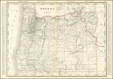
Fantastic color-printed large folding map of Oregon, prepared and printed in Portland in 1904.
The map includes survey and landform data, but its primary focus is on land ownership and political division. The map records many Indian Reservations, and the state is shown crisscrossed by railroad land grants, and others such as the 30-mile California and Oregon Grant.
The map is a veritable catalog of Oregon mapmakers: the engraver credit reads "Bushong & Co. Map Engravers Portland, Ore."; the imprint line credits J. Thorburn Ross with the copyright; the title lists "Huber and Maxwell Civil Engineers" as the compilers, and The Title Guarantee & Trust Co. as the publisher; and the covers list The J.K. Gill Company as the seller.
On the left of the map is a list of post offices and railroad stations, with township and range locations.
Rarity
OCLC locates 8 examples of the 1904 edition and one of a 1903 edition.

![[Alaska to San Diego and San Qunitin, British Columbia] A Chart Shewing Part of the Coast of N.W. America, with the Tracks of His Majesty's Sloop Discovery and Armed Tender Chatham . . . (First Modern Map of the West Coast of North America)](https://storage.googleapis.com/raremaps/img/small/102067.jpg)