


|
||

|

|
|

|
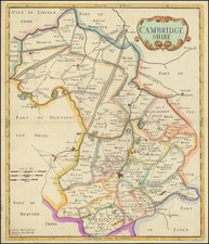
Nice example of Robert Morden's map of Cambridgeshire, showing the county's configuration in the late 17th and early 18th centuries. This map was published by Robert Morden as part of a set of maps showing the layout of the British counties.
The map attractively shows the layout of the county. At the south is Cambridge, which extends only slightly past the Cam River. The Roman Roads of the fenlands are all straight, and are now traced by motorways and A roads. The Gogmagog Hills appear to the southeast. Strangely bisecting the county is "The Hundred Foot Dreine or New Bedford River," one of the remnants of the clearing of the fens. Detail extends into neighboring counties.
Robert Morden (d. 1703) was a British map and globe maker. Little is known about his early life, although he was most likely apprenticed to Joseph Moxon. By 1671, Morden was working from the sign of the Atlas on Cornhill, the same address out of which Moxon had previously worked. Most famous for his English county maps, his geography texts, and his wall maps, Morden entered into many partnerships during his career, usually to finance larger publishing projects.
![[ West Yorkshire ] Ducatus Eboracensis Pars Occidentalis The Westriding of Yorkeshire](https://storage.googleapis.com/raremaps/img/small/80610.jpg)