|
||

|

|
|

|
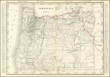
With Annotations Showing A Proposed Railroad to the Columbia River -- One of the Earliest Maps of Oregon Published in Oregon
Scarce separately issued map of Oregon by J.K. Gill, the leading local seller of books and stationary in Portland at the time.
The present example of the map includes extensive annotations in purple, most notably a "Proposed Rail Road from the Central Pacific to the Columbia River," which extends from the Nevada border to the area near Canyon City. Other annotations in the same hand make a meticulous study of the lowlands in the area of a number of rivers and the confluence of several rivers, the vast majority of which are close to the proposed railroad route. In many instances, the are notes remarking on the size of the areas marked in purple, typically 5,000 acres to 10,000 acres, although the largest in the area around Lake Harney are 50,000 and 100,000 acres. While we have been unable to determine the exact purpose of the annotations, given the wide swath of land evaluated and the nature of the study, it seems likely that this was the work of either the Union Pacific or a very well capitalized Oregon venture. The strongest possibility is that the notes relate to Henry Villard's Oregon Railway & Navigation Company and his efforts to work with the Union Pacific between about 1879 and 1885.
The map is hand colored by counties and shows towns, township surveys, topography, rivers, railroads, mountains and other modern details. The treatment of the roads, forts and express stations, etc. is of considerably note.
In northern Baker County, an area is shown with Gold mines, a look at Oregon's richest gold region with a history of mining booms dating back to 1861. A number of Indian Reservations and other Indian tribal information is give. The present map is one of the earliest maps published in the state of Oregon. Rumsey notes:
A scarce, early, large scale map of Oregon that precedes the more referenced (Streeter, Graff) map of 1878. . . . A note at the bottom of the map reads "The Author acknowledges the receipt of valuable information from Col. John Mendenhall, 4th Artillery U.S.A. and Jesse Applegate Esq. respecting the "Modoc Country" and the vicinity of Klamath, Wright and Goose Lakes." Colton was used by Gill to do the engraving and printing; by the 1878 edition, Gill was able to accomplish this in Portland.
![[Washington & Oregon] Amer. Sep. No. 38. Partie Des Etats-Unis](https://storage.googleapis.com/raremaps/img/small/93549.jpg)
![History of the Expedition under the Command of Captains Lewis and Clark, to the Sources of the Missouri Thence across the Rocky Mountains and Down the River Columbia to the Pacific Ocean, Performed During the Years 1804-5-6 [with map:] Map of Lewis and Clark's Track, Across the Western Portion of North America from the Mississippi to the Pacific Ocean](https://storage.googleapis.com/raremaps/img/small/92506.jpg)
![[ Early Automobile Tourism -- Pacific Coast Highways ] (Strip Maps, etc.)](https://storage.googleapis.com/raremaps/img/small/81461.jpg)