


|
||

|

|
|

|
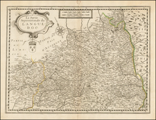
Original antique map from 1651 showing the south of France, from the Midi-Pyrenees region in the west to the Bouches du Rhone in the east. This map was produced in Paris by the great French cartographer Nicolas Sanson, who produced many of the most important French maps of the 17th century.
Mountains are shown pictorially, with the most prominent mountains in the southwest of the map in the Pyrenees region. Cities shown include Toulouse, Narbonne, Perpignan, Cahors, and Beziers.Numerous smaller cities are shown, with the importance of the settlement reflected in their depiction.
Nicholas Sanson (1600-1667) is considered the father of French cartography in its golden age from the mid-seventeenth century to the mid-eighteenth. Over the course of his career he produced over 300 maps; they are known for their clean style and extensive research. Sanson was largely responsible for beginning the shift of cartographic production and excellence from Amsterdam to Paris in the later-seventeenth century.
Sanson was born in Abbeville in Picardy. He made his first map at age twenty, a wall map of ancient Gaul. Upon moving to Paris, he gained the attention of Cardinal Richelieu, who made an introduction of Sanson to King Louis XIII. This led to Sanson's tutoring of the king and the granting of the title ingenieur-geographe du roi.
His success can be chalked up to his geographic and research skills, but also to his partnership with Pierre Mariette. Early in his career, Sanson worked primarily with the publisher Melchior Tavernier. Mariette purchased Tavernier’s business in 1644. Sanson worked with Mariette until 1657, when the latter died. Mariette’s son, also Pierre, helped to publish the Cartes générales de toutes les parties du monde (1658), Sanson' atlas and the first French world atlas.
![[Bay of Biscay] Paskaerte Vande Bocht van Vranckrijck Biscajen en Galissen tuscchen Heylant en C. de Finisterre](https://storage.googleapis.com/raremaps/img/small/83967.jpg)
![[Lyon]. Description Au Naturel De La Ville De Lyon E Paisages Alentour D'Icelle](https://storage.googleapis.com/raremaps/img/small/42402.jpg)