


|
||

|

|
|

|
Original Manuscript Sea Chart by Famed Hydrographer Daniel Ross
Extremely rare chart of the passages on the east side of Banca (Bangka), in Indonesia, from Daniel Ross’ survey of the Gaspar Strait. The chart includes notes by Ross with his initials.
The present chart would seem to be the manuscript original, which was “engraved by John Bateman” and printed by James Horsburgh in London in 1819. The printed chart survives seemingly in a single example at the British Library (Maps 147.e.18.(75.)). The inscriptions on both are identical, noting a credit to "D. Ross, commander in the H.C. Marine, 1818; drawn by M. Houghton.” The printed version includes several more additions by Horsburgh, including notes about the quality of the bottom in the lower right and Canning Island near the title block.
The present chart improves on another chart by Horsburgh, and after Ross’ survey, also printed by order of Parliament on July 1, 1819. The two printed charts suggest that Horsburgh published this more-refined version and an earlier draft simultaneously.
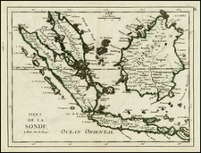
The chart shows Middle Island (Lait), Gaspar Island, and part of the larger Banca (Bangka) Island, with the two featured straits separating the three Indonesian islands that are near Sumatra and Java. In the late eighteenth and early nineteenth centuries, these waters were exceedingly dangerous but also exceedingly tempting for commercial vessels seeking to reach the trading ports of China and Southeast Asia.
The Gaspar Strait was first traversed by an English captain named Hurle in 1702, but was named for a Spanish captain from Manila, who made the passage in 1724. The Clements Strait was named for Captain John Clements, who passed through in 1781, and is also sometimes known as the Billiton Strait, so named for the larger island to the east.
The chart is based in part on an earlier, lower-resolution chart by Alexander's Dalyrmple, Chart of the Passage to the East of Banka Laid down from Observations in Ship Van Sittart'. By Captain Lestock Wilson, 1789. Published by A Dalrymple, 17 March 1792. Dalrymple's chart, published on two sheets, appeared in his East India Pilot.
The aforementioned Captain Wilson and his crew drew sketch charts of the area. One of these charts was available in a voyage account published by mate George Roberston in 1788. William Bligh, of Bounty fame, wrote the following in his Voyage to the South Sea, regarding the sinking of Wilson’s ship, Vansittart, on October 9, 1789 near Bangka:
This day anchored in the road the General Elliot, an English ship commanded by Captain Lloyd. In the Straits of Banca he had met with some boats belonging to the East India Company's ship Vansittart that was lost in the straits of Billaton by having struck on a rock that went through her bottom. Captain Wilson, who commanded the Vansittart, I was informed had just finished a survey of those Straits and was hoisting his boat in when the ship struck. Immediately on receiving the intelligence Captain Lloyd, in the General Elliot and another ship in company called the Nonsuch, sailed for the wreck. They found the ship had been burnt down to the water's edge by the Malays. They however saved 40 chests of treasure out of 55 which were said to have been on board. Most of the ship's company were saved: one man only was lost in the ship, and five others in a small boat were missing who were supposed to have taken some of the treasure.
Ross called on this all of this pre-existing information, as noted in the references to “Capt. Wilson’s plan” on this chart. However, he also considerably updates the information provided by Captain Wilson, Dalrymple, and others, including a memorandum identifying the safest way to make Gaspar Island. The hazards in this area were no small matter, as the Vansittart’s fate shows. Additionally, on February 7, 1816, when Ross was conducting his survey of the South China Sea, the American ship Fingal, under the command of Captain Vibbert, sank when sailing from Canton to New York. The ship was owned by John Jacob Astor, founder of the famous Astor fortune and dynasty, and its cargo of Chinese porcelain was consigned to the Astor family. The 383-ton copper-sheathed vessel struck a rock in the Gaspar Strait, something this chart hoped to prevent in the future.
This chart includes notes in Ross’ hand which are signed with his initials (under the title and in the section on magnetic variation).
Rarity
All Ross charts are extremely rare. To find a manuscript chart with notes in his hand is exceptional. We were unable to locate another example of this manuscript chart. As noted above, a printed version, dated 1819, is held at the British Library.
The title bears a similarity to the chart listed as #123 (Gaspar and Clements Straits, Captain D. Ross, 1818) in the List of Charts published at the Chart Office, East India House (1848), but we suspect that the chart listed probably refers to the other Horsburgh chart, which closely follows this manuscript example, and was also published in 1819.
Daniel Ross (1780-1849) was a renowned marine surveyor in the service of the East India Company (EIC). His precision and skill were lauded by contemporaries, including those at the Royal Navy’s Hydrographic Office. Clements Markham, explorer and President of the Royal Geographical Society, called him “the Father of the Indian Surveys.”
Ross’ mother, Elizabeth Foord, was a freed slave from Jamaica. His father was a Jamaican merchant, Hercules Ross. His father moved his children to Scotland, where they attended school. At fifteen, in 1795, Daniel joined the Bombay Marine and quickly gained a reputation for being brave, clever, and studious.
Over the next decade, Ross acquitted himself well in EIC ships and, for a time, Royal Navy ships when he was seconded from 1797-8. Promoted second lieutenant in 1800, Ross quickly proved himself adept at fighting pirates and rivals of the Company. He was made first lieutenant in 1804 and commander the following year.
To this point, Ross had earned a reputation primarily as a fighting captain. Given command of the Antelope in 1806, Ross was chosen for a patrol of the waters near Macao because of that reputation; however, the mission was also to survey ports of refuge when time allowed. This began an important fourteen-year period of hydrographic work in the South China Sea. Paired with Lieutenant Philip Maughan, also a skilled nautical surveyor, Ross and his crew brought many of the area’s tricky passages and coveted ports to light for the first time. Of his colleague, Maughan said:
Concerning Captain Daniel Ross’s labours in the China Seas from 1806-1820 believe me the British Merchants Trading to China and the Captains and ships owe much to his scientific exertions…no fatigue night or day damped his ardour to benefit his country – I was with him most of the time & witness to his exertions…He carried out all his surveys on a trigonometrical basis; all his angles were checked with sextant and his triangulation frequently checked by astronomical observations. (as quoted in Agnes Butterfield, Captain Daniel Ross (1982), 5; manuscript at the Royal Society)
Ross gained wide approbation for this work. Captain Jervis of the Bengal Engineers stated at a meeting of the British Association for the Advancement of Science (August 26, 1838):
The maritime surveys which have been made by the East India Company's naval officers are honourable to the spirit of the great public body whose desire they were instituted. A series of charts of the entire coast of China, by my friend Captain Daniel Ross, Indian Royal Navy, and others, illustrating the ports, rivers and coasts, from Cochin China and throughout the Malayan Archipelago to the confines of India, by Captains Crawford, Robinson and Ross, are highly useful to the navigators who frequent those seas.
He was elected a Fellow of the Royal Society in 1822 and, a year later, appointed Marine Surveyor General at Calcutta (Kolkata). Between 1823 and 1833 he superintended the surveying of the Red Sea and the Persian Gulf. Ross held the position until his resignation in 1833, when he retired to Bombay (Mumbai) to serve as the Master Attendant (Harbor Master). There he served as President of the Geographical Society of Bombay from 1838-1845. In declining health, Ross resigned his post in 1848; he died the following year.
Between 1805 and 1833, he and his crews completed 46 charts. These would form the basis of Horsburgh’s famed India Directory. Ross was also a pioneer in the nascent science of tidology, playing a role in the publication of the first tide tables in 1833. His works are much sought-after today and they are only rarely found on the market.
![[ Southeast Asia ] Tabula Nova Indiae orientalis & meridionalis](https://storage.googleapis.com/raremaps/img/small/100399.jpg)
![[ Spice Islands--Celebes, Gilolo, etc. ] [Published in Manila!]](https://storage.googleapis.com/raremaps/img/small/58611.jpg)
