Sign In

- Or use -
Forgot Password Create Account
This item has been sold, but you can enter your email address to be notified if another example becomes available.
Description

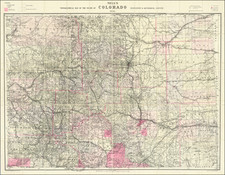
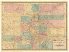
Gunnison Surveys in Western Colorado in 1853

Important early sketch map of the area from the Colorado Rocky Mountains to the Grand Junction area and Northwestern Utah.

Centered on the headwaters of the Arkansas River (flowing east) and the Grand River (flowing west), the map captures the Continental Divide and highest of Colorado's peaks in a remarkable overview.

The map covers the early surveys in search of prospective routes for the Transcontinental Railroad, and would serve as a precursor for the Gunnison & Beckwith map (TMW #842) of the area from St. Louis to San Francisco.  The present map is on a much larger scale, showing Gunnison's route from the Arkansas River valley through the modern La Vita Pass, Garland, Gunnison and the vicinity of Grand Junction. The last camp shown on the map is dated September 20th, 1853. Five weeks, later Gunnison and Kern were killed near Siever Lake, Utah.  

This map was issued in the scarce, preliminary octavo edition of the Pacific Railroad Surveys that preceded the quarto edition by over a year.

Gunnison-Beckwith Expedition

On May 3, 1853, Captain John Williams Gunnison was ordered to lead an expedition to survey a route for a Pacific railroad between the 38th and 39th parallels. The surveying party left St. Louis, Missouri, in June 1853 and arrived by mid-October in Manti, Utah Territory. In Utah Territory, with Lieutenant E. G. Beckwith as assistant commander, Gunnison began the survey of a possible route, surveying areas across the Rocky Mountains via the Herfano River, through Cochetopa Pass, and by way of the present Gunnison and Green rivers to the Sevier River. His journey took him through the Tomichi Valley in Colorado, where the town of Gunnison is named in his honor. After crossing the Tomichi Valley, the survey team encountered the Black Canyon, carved by the Gunnison River which was also named in his honor. The team was forced to turn South to get around the canyon.

The weather was beginning to turn "cold and raw" with snow flurries and Captain Gunnison sought to speed up mapping before returning to winter quarters. At Lake Sevier, the team was divided into two detachments. On the morning of October 26, 1853, Gunnison and the eleven men in his party were attacked by a band of Pahvants (Ute) and Gunnison and seven others were killed.  Killed with Gunnison were Richard H. Kern (topographer and artist), F. Creuzfeldt (botanist), Wiliam Potter (a Mormon guide), Private Caulfield, Private Liptoote, Private Mehreens, and John Bellows (camp roustabout.).

Most contemporary accounts provide that the Mormons warned Gunnison that his party might be in danger from local bands of Pahvant Utes. It seems that Gunnison had entered Utah in the midst of the Walker War, between the Mormons and the Ute Chief Walkara. Lt. Beckwith later wrote that the expedition found the local Mormons "all gathered into a village for mutal protection against the Utah Indians." Late, rumors circulated that the Pahvants were acting under the direction of Brigham Young and an alleged secret militia known as the Danites. Some claim that leaders of The Church of Jesus Christ of Latter-day Saints were initially concerned that the railway would increase the influx of non-Mormon settlers and non-Mormon economic concerns into the territory. However, the Utah Legislature (dominated by LDS officials) had repeatedly petitioned Congress for both a transcontinental railroad and telegraph lines to pass through the region. When the railroad finally came to Utah, LDS leaders organized cadres of Mormon workers to build the railway, welcoming the income for the economically depressed settlers.

Martha Gunnison, widow of Captain Gunnison, was one of those who maintained that the attack was planned and orchestrated by militant Mormons under the direction of Brigham Young. Gunnison's letters to his wife throughout the expedition left her with the impression that "the Mormons were the directors of my husband's murder." She wrote to Associate Justice W.W. Drummond, the 1855 federal appointee to the Supreme Court of the Territory of Utah. She received confirmation of this belief in his response to her letter. Drummond drew this conclusion from informant and witness testimonies in several trials after the murders. He cited numerous reports by whites and natives of white attackers dressed up as Indians during the massacre.

However, Lt. Beckwith concluded that the Mormons had nothing to do with the attack. He wrote in his official report that the "statement which has from time to time appeared (or been copied) in various newspapers...charging the Mormons or Mormon authorities with instigating the Indians to, if not actually aiding them in, the murder of Captain Gunnison and his associates, is, I believe, not only entirely false, but there is no accidental circumstance connected with it affording the slightest foundation for such a charge."

Nevertheless, the Gunnison Massacre resulted in much controversy and added additional strain to the relationship between Governor Brigham Young of the Utah Territory and the Federal Government. This incident and related events, including the Mountain Meadows massacre, where Mormons killed over 100 settlers of the Baker-Fancher wagon train, eventually culminated in the Utah War, wherein President Buchanan sent the U.S. Army to the Utah Territory in order to stop a reported Mormon insurrection.

U.S. Pacific RR Surveys Biography

The twelve-volume work Reports of Explorations and Surveys to Ascertain the Most Practicable and Economical Route for a Railroad from the Mississippi River to the Pacific Ocean, commonly known as the U.S. Pacific Railroad Surveys, stands as one of the most comprehensive and ambitious survey projects of 19th-century America. Conducted between 1853 and 1855, the surveys were commissioned by the U.S. War Department to explore and document potential routes for a transcontinental railroad. The project was of immense logistical scale and engaged some of the foremost scientists, engineers, and cartographers of the period. Their work provided a meticulously detailed examination of the topography, geology, natural resources, and native populations of the vast western territories, producing a landmark study that shaped the expansion of American infrastructure and industry.

The U.S. Pacific Railroad Surveys encompassed five major exploratory routes across the western United States, each corresponding to different potential paths for the transcontinental railroad. These included surveys through the northern territories from the Great Lakes to Puget Sound, central and southern routes traversing the Rocky Mountains and Sierra Nevada, and a route running along the 32nd parallel near the Mexican border. The selection of these corridors was strategic, aimed at finding the most feasible passages across the varied landscapes while balancing the interests of northern, southern, and western states and territories. The territories explored ranged from the Great Plains, stretching through rugged mountain passes, to the arid deserts of the Southwest and the coastal lowlands along the Pacific, all meticulously recorded in reports, sketches, and maps.

The northernmost route, surveyed by Governor Isaac I. Stevens of Washington Territory, investigated a path from St. Paul, Minnesota, across the northern plains, through the Rocky Mountains at Marias Pass, and to Puget Sound.  Stevens’ survey is especially notable for its contributions from naturalists like George Suckley and John G. Cooper, who meticulously cataloged the flora and fauna encountered. Additionally, Stevens was a proponent of indigenous cooperation, advocating negotiations with Native American tribes to establish safe passage along the proposed route.

In the central region, John W. Gunnison led an expedition through the 38th parallel, traveling from St. Louis across Kansas and Colorado, into the rugged terrain of Utah, and finally into the Sierra Nevada. Tragically, Gunnison was killed during a skirmish with local Native Americans, and the survey was completed by Lieutenant Edward Griffin Beckwith. Gunnison and Beckwith’s reports are particularly valuable for their surveys of the Wasatch Range and for the inclusion of detailed maps that influenced later routes through the Great Basin and Salt Lake Valley.  

Further south, the survey of the 35th parallel was led by Lieutenant Amiel Weeks Whipple, who documented the region extending from the Arkansas River through New Mexico and Arizona to the Pacific Ocean. Whipple’s route traversed desert regions and rugged landscapes, including the Colorado River basin. Whipple's survey also notably included artists like Heinrich Balduin Möllhausen, whose depictions of the landscapes and indigenous communities provided visual insights that were critical for Eastern audiences.

The southernmost route, following the 32nd parallel along what would become the Southern Pacific Railway corridor, was led by John Pope and pursued a path from the Red River to the Rio Grande and through Arizona and Southern California. This survey was strongly supported by Southern legislators, as it followed a path that could support a southern transcontinental link and presented fewer winter weather challenges compared to the northern routes. The reports from this route highlighted the unique topography of the Sonoran Desert and the California coastal plains.  

In addition to the geographic explorations, the project saw significant contributions from leading cartographers and naturalists who produced groundbreaking work in mapmaking and scientific documentation. The primary cartographer was Lieutenant Gouverneur K. Warren, who oversaw the integration of the collected data into comprehensive maps. Warren's meticulous maps synthesized data from all five routes, resulting in the production of some of the most accurate and detailed maps of the American West at the time. His work was instrumental in consolidating information on the vast, uncharted territories, transforming raw survey data into accessible and invaluable resources for future expeditions and developments.

Several artists, including Möllhausen and F.W. Egloffstein, a German-born topographer, provided a visual dimension to the Pacific Railroad Surveys. Egloffstein’s contribution was pioneering; he used photolithography to create shaded relief maps, an innovation that added depth and realism to the depictions of the western terrain. His maps, particularly of the Great Basin, are considered some of the earliest examples of printed relief maps, giving readers in the East a tangible sense of the rugged landscapes and the formidable task of constructing a railroad through such regions. 

The Pacific Railroad Surveys ultimately represented a collaborative effort that blended military precision, scientific rigor, and artistic skill to document the vast American landscape. While the route eventually chosen for the transcontinental railroad would follow a central corridor through Wyoming, the surveys influenced the development of future transportation corridors and provided foundational knowledge about the American West.