|
||

|

|
|

|
Stock# 84364
Description
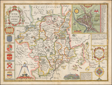
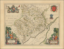
Valk and Schenk's map of southern England covering Hampshire and Berkshire, with west at the top. This nice, decorative map was published by Valk and Schenk at the end of the 17th century, and was originally engraved in circa 1636 by Jansson.
The detail on the map is nice, with forests, towns, hundreds, and more all shown. The cities shown include Southampton and Winchester. The detail extends into the neighboring counties of Dorsetshire, Wiltshire, Oxfordshire, and the Isle of Wight.
Condition Description
Original hand-color in outline with later color in the decorative elements. Minor manuscript facsimile near Hambledon.