


|
||

|

|
|

|
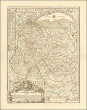
Original antique map of the region to the west of Lyon, in central France. This beautiful region is shown on this delicately engraved and marvelously hand-colored map from the 17th century, published in Paris by Nicolas Sanson at the auspices of Pierre Mariette.
The map shows the region bounded by the Rhone River to the east and the Vienne River to the west. Cities shown on the map include Clermont-Ferrand, Brioude, Lyon, Vichy, Nevers, and Moulins. Topography, forests, hydrography, and other features are shown. The map includes a delicate cartouche in the upper right.
Nicholas Sanson (1600-1667) is considered the father of French cartography in its golden age from the mid-seventeenth century to the mid-eighteenth. Over the course of his career he produced over 300 maps; they are known for their clean style and extensive research. Sanson was largely responsible for beginning the shift of cartographic production and excellence from Amsterdam to Paris in the later-seventeenth century.
Sanson was born in Abbeville in Picardy. He made his first map at age twenty, a wall map of ancient Gaul. Upon moving to Paris, he gained the attention of Cardinal Richelieu, who made an introduction of Sanson to King Louis XIII. This led to Sanson's tutoring of the king and the granting of the title ingenieur-geographe du roi.
His success can be chalked up to his geographic and research skills, but also to his partnership with Pierre Mariette. Early in his career, Sanson worked primarily with the publisher Melchior Tavernier. Mariette purchased Tavernier’s business in 1644. Sanson worked with Mariette until 1657, when the latter died. Mariette’s son, also Pierre, helped to publish the Cartes générales de toutes les parties du monde (1658), Sanson' atlas and the first French world atlas.

![[French Riviera and Corsica]](https://storage.googleapis.com/raremaps/img/small/78104.jpg)
![[Lyon]. Description Au Naturel De La Ville De Lyon E Paisages Alentour D'Icelle](https://storage.googleapis.com/raremaps/img/small/42402.jpg)