


|
||

|

|
|

|
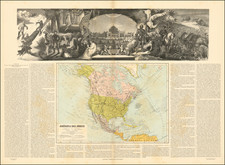
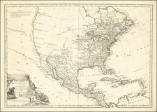
The First Printed Map to Name the United States (Etats-Unis)
Nice example of Esnauts & Rapilly's landmark American map, generally regarded as the first map to name the United States.
This map and Lattre's map are considered the two earliest maps to use the name Etats-Unis (United States) in the title of the map.
The map delineates United States in the midst of the American Revolution, but shows a very unusual "Floride Occidente, which extends north to the mountains of North Carolina, claiming all of the future Mississippi and Alabama as part of West Florida. The region between the Mississippi and Appalachians, south of the Great Lakes, remains filled with French Forts.
A note along the Mississippi River, just south of the mouth of the Missouri River, a note reads:
Missi-sipi F qui sert de bornes aux Dominations Espagnoles et Anglo-Américaine
(Mississippi River which serves as the limits to the Spanish and Anglo-American Dominations).
West of the Great Lakes and Lac Ouinipigon (Winnipeg), the River of the West is still shown, extending toward Drake's Nouvelle Albion, with Quivia and the R. Colorado de las Martyrs shown further south. The west coast is a mix of mythical discoveries (De Font/Fuente, Juan de Fuca and Martin d'Aguilar) and the Russian discoveries.
The appearance of "Puerto de S. Francisco" is an unusual anomaly. First, it is placed well north of its true location. More interestingly, it is likely the third appearance of San Francisco Bay on a printed map, pre-dated only by Miguel Costanso's Carta Reducida Del Oceano Asiatico, Ó Mar Del Sur, Que Comprehende La Costa Oriental Y Occidental De La Peninsula De La California), (1771) and a map of America by Lopez dated 1772. The rest of the cartographic world remained ignorant of the existence of San Francisco Bay until 1790, when a copy of Costanso's map was acquired by Alexander Dalrymple in England, who thereafter published an English copy.
There are several later more common editions of the map, including one dated 1783 and one dated 1796 (An VII, in the year of the French Republic).
Rarity
The map is rare on the market. AMPR / oldmaps.com locates 2 examples in dealer catalogs in the past 30 years (1999 and 2001, quite possibly the same example) and 1 copy at auction (2001).
Louis Brion de la Tour (ca. 1743-1803) was a French geographer and demographer. Little is known about Louis’ early life, but some glimpses of his professional life survive. He did achieve the title of Ingénieur Géographe du Roi. Much of his work was done in partnership with Louis Charles Desnos, who was bookseller and geographical engineer for globes to the Danish Crown. He worked on the Indicateur fidèle ou guide des voyageurs, qui enseigne toutes les routes royales between 1762 and 1785. During his career he also worked on several atlases. By 1795, he had gained a pension from the National Assembly. Perhaps this pension was granted in part because his son, also Louis Brion de la Tour (1763-1823), was an engraver who made Revolutionary prints, as well as maps.
![[ First Map to Name The United States ] L'Amerique septentrionale ou se remarquent les Etats Unis . . . 1779](https://storage.googleapis.com/raremaps/img/small/94192.jpg)