|
||

|

|
|

|
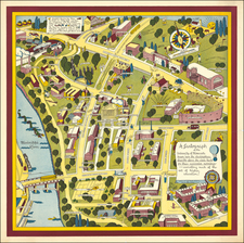
An exceptional example of Arthur Zaidenburg's 1939 map of Lower Manhattan, focusing on the Colonial, Revolutionary, and 19-century history of New York City.
Arthur Zaidenburg (1903-1990) worked with Gardner Osborn, the New York historian, to publish this map for the 1939 New York World's Fair.
The map is somewhat reminiscent of the earliest manuscript maps of Manhattan such as the 'Duke's Map' or the Bellin Nouvelle-Yorck, and the numerous cartoon figures and notes on the map illustrate dozens of important historical events. The map shows George Washington leaving Faunces Tavern (the 1939 World's Fair was on the 150th Anniversary of Washington's Inauguration); the Wall of Wall Street; the various 19th-century fires; etc.
Arthur Zaidenburg also published a map of Paris in 1930 (see Rumsey 12151).
![[Revolutionary War Plans of New York, Boston, Charleston, Delaware River to Philadelphia & Havana] Various Plans and Draughts of Cities, Towns, Harbours &c . . .](https://storage.googleapis.com/raremaps/img/small/83450.jpg)