|
||

|

|
|

|
Stock# 84227
Description
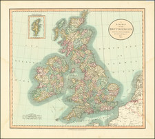
Attractive example of Wilkinson's first map of the British Isles, showing counties, towns, rivers, lakes, islands, et cetera.
Robert Wilkinson was active in London as a cartographic publisher from 1785 to 1825. He produced a number of nice works, including a General Atlas and a re-issuance of Bowen & Kitchen's English Atlas, along with excellent large format separate maps.

![[ British Islands ] Wight / Scilly / Jersey / Guernsey / Alderney / Man / Holy / Farne ] The Smaller Islands in the British Ocean](https://storage.googleapis.com/raremaps/img/small/98973.jpg)