|
||

|

|
|

|
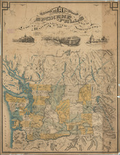
Interesting mid-century aerial map of the Port of Seattle, published by the Port, showing the city and port just before a period of major urban change when Highway 5 and the Alaskan Way Viaduct were complete by 1960.
The map lists a total of 91 piers and their associated companies.
In the 1950s, the Port of Seattle was experiencing significant growth and development, driven by post-World War II economic expansion and the increasing importance of maritime trade. The port invested heavily in modernizing its facilities, including constructing new piers, warehouses, and cargo-handling equipment to accommodate the growing volume of cargo and passenger traffic.
During this period, the Port of Seattle played a vital role in facilitating international trade, especially with Asia, and served as a critical gateway for exports and imports. The port also supported the local economy by providing jobs and stimulating industries such as fishing, shipbuilding, and logistics. The 1950s set the stage for the Port of Seattle's continued growth and evolution into a major hub for global trade and transportation in the following decades.

![Johnson's Washington Oregon and Idaho [Massive Dakota Territory]](https://storage.googleapis.com/raremaps/img/small/98348.jpg)