
With a Beautiful Plan of New Orleans
Norman's guidebook to New Orleans lives up to its subtitle, presenting a rich compendium of information on "all subjects of general interest to the southern metropolis," including an account of its early history and settlement. The easy flowing text contains historically interesting descriptions that resonate to this day:
The view of New Orleans from the river, in ascending or descending, is beautiful and imposing- seen from the dome of the St. Charles Exchange, it presents a panorama at once magnificent and surprising. In taking a lounge through the lower part of the city, the stranger finds a difficulty in believing himself to be in an American city - page 69.
A section titled Excursions provides information on surrounding areas such as Carrolton, Macdonough, and nearby racecourses (the Louisiana, near Lake Pontchartrain; the Metairie; and one at Carrolton).
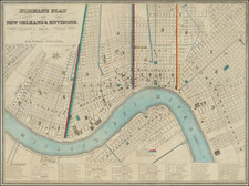
The beautiful and fine folding plan, engraved by Shields & Hammond in New Orleans is a famous mid-19th century mapping of the city. Henry Moellhausen (or Mollhausen), an important early surveyor and architect, mostly active in the 1840s, is credited with drawing the "original draught" of the plan. His plan shows the city divided into three districts, with boundaries marked with double green and pink lines. The Mississippi River is nicely colored in blue watercolor wash. An index key printed in the lower margin of the map identifies 80 numbered buildings and sites, including hotels, exchanges, banks, churches, theatres, hospitals, markets, cotton presses, and public buildings.
In addition to the large folding plan of New Orleans, there are two additional maps within the text: New Orleans in 1728 and Environs of New Orleans, the latter showing Lake Pontchartrain, Lake St. Catharine, and Lake Borgne, as well as the steamboat lines into New Orleans. Also notable is the engraved frontispiece view of the New Orleans waterfront showing several tall-masted sailing ships, a small flatboat, a paddle steamer, and a few people in the foreground, including a pair of well-dressed merchants or planters and three African Americans (including a woman). According to the preface, the various engravings illustrating the book are after original artwork made especially for this work by a Mr. Cowell.
Sabin and Howes fail to mention the large folding plan, which suggests that copies of Norman's guidebook were not always issued with the map.
An important early descriptive work on New Orleans with a fine mid-19th century plan showing the urban expansion of the city up to the date of publication.