|
||

|

|
|

|
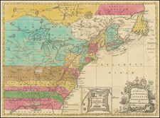
Unusually Fine Example of the Rare 1852 State of Monk's Wall Map of the U.S. With the Plains as a Rainbow of Indian Territories.
Important wall map of the United States showing the states and territories of the newly conquered American Southwest and published the year before the Gadsen Purchase.
The map is notable for several reasons, but most unusual is the panoply of colors present in the Plains between Oklahoma and the Canadian border. This representation of the region, derived from the exceedingly rare 1847 Monk and Sherer wall map, is very uncommon to see on wall maps and preserves the pre-Kansas-Nebraska Act configuration of the Plains territories. The map names the tribal lands of the Chickasaws, Choctaws, Pawnees, Kanzas, Delaware, Omaha, Sioux, and Cheyenne indigenous peoples (among others). For those that were resettled, their native lands are denoted, e.g., the Cherokee are "From Georgia." Populations of each territory are named. Cutting through these territories are routes, including the "Emigrant's Route to Oregon," not present in the Monk and Sherer editions.
Jacob Monk's maps of North America were perhaps the single most popular series of large-format maps of North America published in the 1850s. Monk's map was first issued in 1851 and was updated yearly or more for the better part of a decade. As one of the most widely distributed wall maps of the United States from the 1850s, it is a map that defined Americans' vision of the West.
The detail on the American West is fine in the "Gold Region," which shows a mass of diggings, settlements, and other geography extending from the crest of the Sierra Nevada to the San Joaquin and Sacramento Rivers. The Utah Territory extends from Long's Peak to the Sierra Nevada, with the Mormon settlements noted in the vicinity of the Great Salt Lake.
Texas is shown in fine detail, with the Fisher & Miller Colony and "German Settlements" upriver of Austin, a coal bed near the headwaters of the Nueces River, and the Cross-Timbers depicted pictorially. Further north, along the Santa Fe Trail, a curious "Fan Land District" is shown.
Wheat terms the map "showy," likely referring to the many decorative elements, including the mid-19th-century ships throughout the oceans. An inset world map appears in the lower left, with early colonies appearing in Africa. A list of all the counties and county towns in the United States can be found to the right. The map also includes a table of distances.
Further Notes on the 1852 State
Stanford University notes that states are known from 1851, 1852, 1853 (two states), 1854 (again two states), 1856, 1857, and 1858. An 1850 edition is hypothesized but not known. The 1851 edition is exceedingly rare (no records in OCLC), making this the first obtainable (but still relatively scarce) edition.
The 1852 state is the last to show the different Indian nations colored differently in the Plains; in the 1853 state, they are replaced with the "Nebraska Territory as Proposed." This edition also shows the Oregon Territory as a single mass without the Washington Territory, which is added in the 1853 edition. The Gadsden Purchase is, of course, not shown.
![(Canadian-American Boundary) [Group of 11 photographs by Alexander Gardner, including 3 after the British Commission's 1860-61 photographs, for the North American Boundary Commission Survey along the 49th Parallel, used in settling Hudson's Bay Co. claims in the British and American Joint Commission]](https://storage.googleapis.com/raremaps/img/small/95481.jpg)