|
||

|

|
|

|
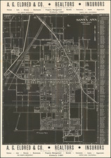
Stock# 84132
Description
Excellent early map of Santa Ana, compiled by its City Engineer, W.L. Steward in 1906 and drawn by C.D. Butler, and later updated by G.L. Bates, the City Engineer in 1907.
This is the reduced size edition of the map was printed by George L. Bates in Santa Ana, likely printed in 1907.
Includes a number of colored annotations, showing the future lines of the the Southern Pacific Railroad. Lists a number of early subdivisions.
Condition Description
Minor loss along folds.