|
||

|

|
|

|
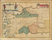
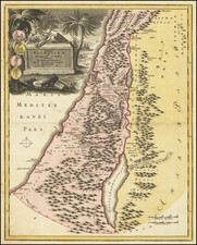
Finely engraved map of the region covering the area from eastern Mediterranean to the Persian Gulf.
The map is based on the Ortelius/Vrients map of this title designed by Franciscus Haraeus, which appeared in late editions of the Parergon.
The map covers the area from Turkey and the Caucasus to the region north of the Black Sea. Details include the pyramids in Egypt, the route of Abraham from Ur to Sichem, and the wandering of the Children of Israel.
A large inset map of the Holy Land is shown at the right.
Provenance: Leonard & Juliet Rothman Collection.
Jan Janssonius (also known as Johann or Jan Jansson or Janszoon) (1588-1664) was a renowned geographer and publisher of the seventeenth century, when the Dutch dominated map publishing in Europe. Born in Arnhem, Jan was first exposed to the trade via his father, who was also a bookseller and publisher. In 1612, Jan married the daughter of Jodocus Hondius, who was also a prominent mapmaker and seller. Jonssonius’ first maps date from 1616.
In the 1630s, Janssonius worked with his brother-in-law, Henricus Hondius. Their most successful venture was to reissue the Mercator-Hondius atlas. Jodocus Hondius had acquired the plates to the Mercator atlas, first published in 1595, and added 36 additional maps. After Hondius died in 1612, Henricus took over publication; Janssonius joined the venture in 1633. Eventually, the atlas was renamed the Atlas Novus and then the Atlas Major, by which time it had expanded to eleven volumes. Janssonius is also well known for his volume of English county maps, published in 1646.
Janssonius died in Amsterdam in 1664. His son-in-law, Johannes van Waesbergen, took over his business. Eventually, many of Janssonius’ plates were sold to Gerard Valck and Pieter Schenk, who added their names and continued to reissue the maps.
![[Iskenderun] The Gulf of Alexandretta or Scandaroon](https://storage.googleapis.com/raremaps/img/small/73675.jpg)