


|
||

|

|
|

|
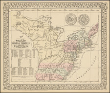
Shows The First Mormon Settlement In Texas
Interesting German language guide map of the United States, published by Otto Wigand in Leipzig, which includes the location of Zodiac, Texas, the first Mormon Settlement in Texas.
The map extends west to Texas and a massive Indian Territory, which extends north to the North-West Territory, which would shortly thereafter become Nebraska Territory. The map also includes a large inset map of the Transmississippi West and smaller insets of Cuba, Havana and the area around the Niagara River.
The western part of the map is filled with large swaths of land which was then occupied by Native Americans, many of whom had been relocated in the prior decades from points further east. In addition, dozens of western forts are shown, along with an elaborate representation of the Upper Missouri River Valley and its tributaries. The area south of Lake Superior is labeled Mineral Region, one of several notes encouraging the prospect of immigration to the region.
In Texas, several colonies are located, including an area entitled "German Settlements" and an area west of Austin City labeled "Zodiac" (Mormon Settlement)", the first attempt by the Church of Latter Day Saints to establish a settlement in Texas.
Zodiac, Texas
Zodiac is a short-lived Mormon or Latter Day Saint settlement established in 1847, 4 miles southeast of Fredericksburg, Texas on the Pedernales River. This was the first attempt to establish a Latter Day Saint colony, and was le by Lyman Wight, an apostel and prominent leader of the LDS church during its time in Wisconsin. Wight obtained John O. Meusebach's permission to settle near Fredericksburg, where the settlers built the first gristmill and sawmill in Gillespie County and supplied neighboring German colonists with seeds, flour, and lumber. By 1850, the population of Zodiac was 161. The initial location failed after flooding destroyed the mills in 1853, forcing the settlers to relocate to Mormon Mill, in Burnet County.
![[Whoever is silent is Complicit -- Anti-Vietnam / Anti-American Poster] Vietnam: Sterminio | chi tace è complice](https://storage.googleapis.com/raremaps/img/small/89365.jpg)
![[Map of the United States, illustrating the routes of the Canadian Pacific Railway and the Seattle, Lake Shore and Eastern Railway]](https://storage.googleapis.com/raremaps/img/small/71080.jpg)
![[ Rotary Club International ] USCB Districts of Rotary International as of 1 July, 1958](https://storage.googleapis.com/raremaps/img/small/90418.jpg)