|
||

|

|
|

|
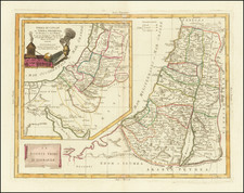
Rare separately published educational map of the Holy Land, published in Paris and was probably intended to be used with Analyse géographique de la carte de la Palestine, published in the same year. by AH Dufour and Charles Picquet, both of whose names appear on this map.
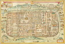
The map includes a large inset plan of Ancient Jerusalem and a fragment of the famed Peutinger route map, showing the area of the map which covers the Holy Land and the Roman roads.
The title notes that the map was approved by the Royal Council for the purpose of public instruction, a very unusual inscription for a map published in France in the early 19th Century.
Rarity
The map apparently quite rare. We note that Rumsey shows an edition of 1830.
We find no examples offered at auction or in dealer catalogs.
The Analyse géographique de la carte de la Palestine is also seemingly very rare. The map is not in the BnF.
![[ Maccabee Tomb ] Grafgebouw Der Makkabeen Opgeregt Te Modin](https://storage.googleapis.com/raremaps/img/small/101602.jpg)