|
||

|

|
|

|
With Maps of California and Oakland by Grafton Tyler Brown, the first African-American lithographer in California
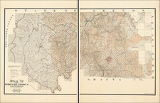
A rare promotional work, with excellent maps of Oakland and California's early railroad systems, providing descriptions of the various railroad lines and all manner of information concerning the city of Oakland.
The text describes the advantages of the city, water and infrastructure, general agricultural and industrial prospects and the like. It is interesting to note that the University of California is also described since it had not yet relocated from Oakland to Berkeley.
The two railroad maps of California and the Oakland were published by Grafton Tyler Brown, California's first African-American lithographer and a noted artst. Brown came to California in 1858, initially working as a hotel porter. Having learned lithography as a teenager while working for a Philadelphia lithographer, he eventually worked for the firm of Kuchel & Dressel from 1861 to 1864. Upon the death of Charles Kuchel, he bought out his erstwhile employer, renaming the firm G. T. Brown & Company. Brown printed advertisements, maps, and other printed items for clients throughout the 1870s. In 1878 he issued The Illustrated History of San Francisco, which contained topographical views of the city. Brown maintained his business on Clay Street in San Francisco, but lived in Oakland after 1874. He later became a painter, specializing in landscape scenes of the Pacific Northwest and California.
The California map, Map of California Showing the Railroad System, shows some topographical detail, but its main feature is the various railroads, actual and proposed, in California. Includes the Memphis & El Paso (terminating in San Diego), Southern Pacific, Humboldt & Colorado, Central Pacific, Western Pacific, Napa Valley and California Pacific. Several proposed routes were never actually established. There are a number of early forts listed, several ghost towns and other ephemeral boom towns (Copperopolis, San Carlos, Knight's Ferry, Virginia City) and other interesting features. Ft. Crook, Ft. Reading, Ft. Mojave, Ft. Yuma are shown. Anaheim is named--one of the first references we have seen on a map. Engraved by F.C. Hafenrichter.
The Oakland map focuses on the towns of Oakland, Brooklyn and Alameda, along with railroad lines and areas reserved for the Central Pacific Rail Road, with a larger inset of a section of San Francisco Bay.
Rarity:
Though fairly well repesented in institutional confines (WorldCat records more than twenty copies), this pamphlet and its maps are quite rare in the market.
An important item for the history of the development of California's railroad system, as well as for Oakland, and for the two very attractive maps by Grafton Tyler Brown.
Grafton Tyler Brown, perhaps the first African American artist to depict California and the Pacific Coast, was born in Harrisburg, Pennsylvania, February 22, 1841. Before he was twenty, Brown moved to San Francisco and learned the art of lithography from C. C. Kuchel. In 1861 and again in 1864, Brown created the two earliest bird's eye views of Virginia City. At the age of twenty-six, he established his own firm, G.T. Brown & Co.
At San Francisco, and elsewhere in California, Brown produced skillfully illustrated bank notes, labels, and maps, and stock certificates for Wells Fargo, Levi Strauss and Co., and several mining companies. His significant lithographic production, The Illustrated History of San Mateo County (1878), featured seventy-two views of the county's communities and ranches. Brown traveled throughout Oregon, Washington, Idaho, Wyoming, Nevada, and British Columbia (where he settled in 1882), producing maps and illustrations, including many landscape paintings.
In 1893, Brown secured employment as a draftsman at the St. Paul, Minnesota office of the U.S. Army Corps of Engineers. Sometime during his St. Paul years he married Elberta Brown. Brown's work with the Corps of Engineers ended in December 1897, after which he worked in the civil engineering department of the city of St. Paul until 1910. He died on March 3, 1918, in Nicollet County, Minnesota, bringing to a close a rich and varied career as an artist and illustrator of the American West.

![The Mother Lode of California [Guide to the Mother Lode Mariposa to Downieville]](https://storage.googleapis.com/raremaps/img/small/97535.jpg)
![[ World Atlas -- Extra Illustrated ] The World Described; or, a New and Correct Sett of Maps: Shewing, the Kingdoms and States in all the known Parts of the Earth](https://storage.googleapis.com/raremaps/img/small/90102.jpg)